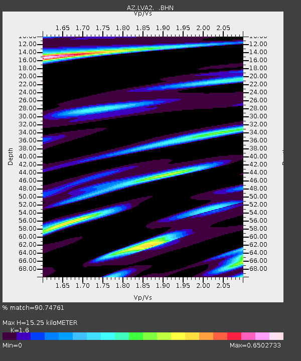
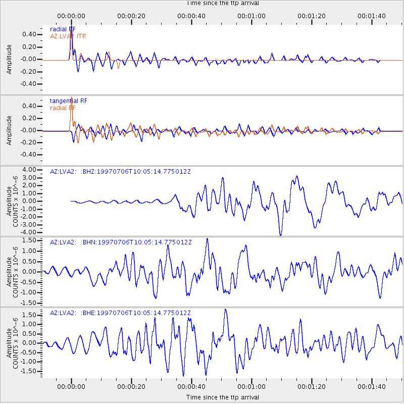
LVA2 AZ.LVA2 - Earthquake Result Viewer

Earthquake location: Near Coast Of Central Chile
Earthquake latitude/longitude: -30.1/-71.9
Earthquake time(UTC): 1997/07/06 (187) 09:54:00 GMT
Earthquake Depth: 19 km
Earthquake Magnitude: 5.8 MB, 6.5 MS, 6.8 UNKNOWN, 6.4 ME
Earthquake Catalog/Contributor: WHDF/NEIC
Network: AZ ANZA Regional Network
Station: LVA2 AZ.LVA2
Lat/Lon: 33.35 N/116.56 W
Elevation: 1435 m
Distance: 75.9 deg
Az: 322.638 deg
Baz: 141.055 deg
Ray Param: 0.05132271
Estimated Moho Depth: 15.25 km
Estimated Crust Vp/Vs: 1.60
Assumed Crust Vp: 6.264 km/s
Estimated Crust Vs: 3.915 km/s
Estimated Crust Poisson's Ratio: 0.18
Radial Match: 90.74761 %
Radial Bump: 400
Transverse Match: 83.90403 %
Transverse Bump: 400
SOD ConfigId: 9875
Insert Time: 2010-02-26 19:49:02.119 +0000
GWidth: 2.5
Max Bumps: 400
Tol: 0.001

Signal To Noise

ChannelStoNSTALTA
AZ:LVA2: :BHN:19970706T10:05:14.775012Z1.03736261.4079343E-71.357225E-7
AZ:LVA2: :BHE:19970706T10:05:14.775012Z1.66049653.3827936E-72.0372181E-7
AZ:LVA2: :BHZ:19970706T10:05:14.775012Z3.25496653.5755986E-71.0985054E-7
Arrivals
Ps1.5 SECOND
PpPs6.1 SECOND
PsPs/PpSs7.6 SECOND