You are here: Home > Network List > TA - USArray Transportable Network (new EarthScope stations) Stations List
> Station O03D Paynes Creek, CA, USA > Earthquake Result Viewer
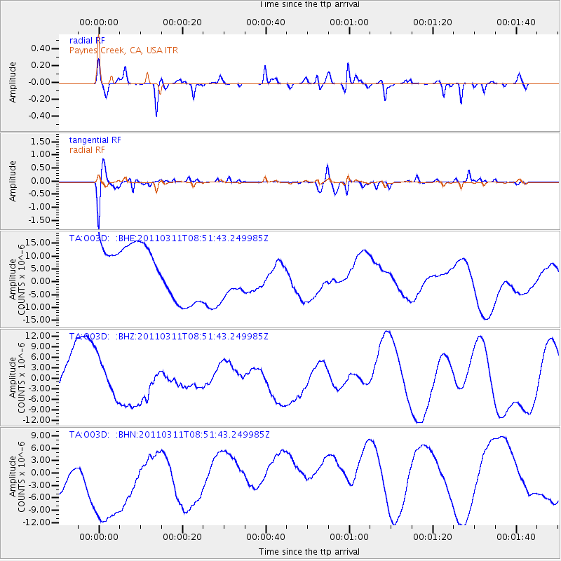
O03D Paynes Creek, CA, USA - Earthquake Result Viewer
*The percent match for this event was below the threshold and hence no stack was calculated.
| Earthquake location: |
Eastern Honshu, Japan |
| Earthquake latitude/longitude: |
37.4/141.0 |
| Earthquake time(UTC): |
2011/03/11 (070) 08:40:56 GMT |
| Earthquake Depth: |
40 km |
| Earthquake Magnitude: |
5.9 MB |
| Earthquake Catalog/Contributor: |
WHDF/NEIC |
|
| Network: |
TA USArray Transportable Network (new EarthScope stations) |
| Station: |
O03D Paynes Creek, CA, USA |
| Lat/Lon: |
40.29 N/121.80 W |
| Elevation: |
968 m |
|
| Distance: |
71.7 deg |
| Az: |
53.046 deg |
| Baz: |
303.745 deg |
| Ray Param: |
$rayparam |
*The percent match for this event was below the threshold and hence was not used in the summary stack. |
|
| Radial Match: |
59.89436 % |
| Radial Bump: |
331 |
| Transverse Match: |
43.971497 % |
| Transverse Bump: |
394 |
| SOD ConfigId: |
356183 |
| Insert Time: |
2011-08-13 22:05:06.060 +0000 |
| GWidth: |
2.5 |
| Max Bumps: |
400 |
| Tol: |
0.001 |
|
Signal To Noise
| Channel | StoN | STA | LTA |
| TA:O03D: :BHZ:20110311T08:51:43.249985Z | 0.6907951 | 5.4923794E-6 | 7.950808E-6 |
| TA:O03D: :BHN:20110311T08:51:43.249985Z | 1.6814709 | 2.0365895E-5 | 1.2111952E-5 |
| TA:O03D: :BHE:20110311T08:51:43.249985Z | 0.89215523 | 8.8505385E-6 | 9.920403E-6 |
| Arrivals |
| Ps | |
| PpPs | |
| PsPs/PpSs | |


