You are here: Home > Network List > TA - USArray Transportable Network (new EarthScope stations) Stations List
> Station G35A Watkins, MN, USA > Earthquake Result Viewer
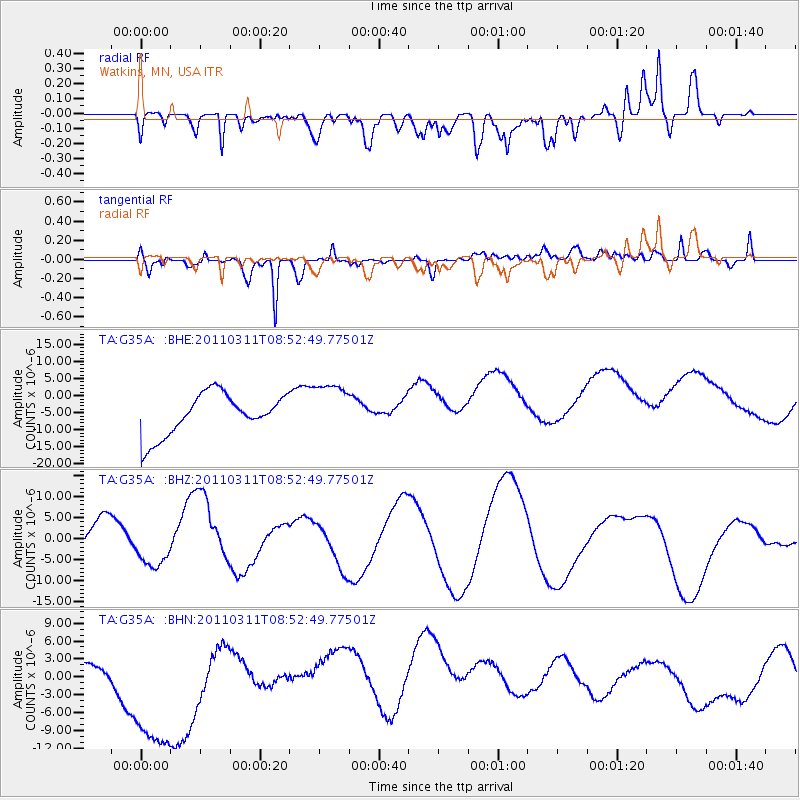
G35A Watkins, MN, USA - Earthquake Result Viewer
*The percent match for this event was below the threshold and hence no stack was calculated.
| Earthquake location: |
Eastern Honshu, Japan |
| Earthquake latitude/longitude: |
37.4/141.0 |
| Earthquake time(UTC): |
2011/03/11 (070) 08:40:56 GMT |
| Earthquake Depth: |
40 km |
| Earthquake Magnitude: |
5.9 MB |
| Earthquake Catalog/Contributor: |
WHDF/NEIC |
|
| Network: |
TA USArray Transportable Network (new EarthScope stations) |
| Station: |
G35A Watkins, MN, USA |
| Lat/Lon: |
45.22 N/94.49 W |
| Elevation: |
361 m |
|
| Distance: |
83.7 deg |
| Az: |
35.858 deg |
| Baz: |
318.728 deg |
| Ray Param: |
$rayparam |
*The percent match for this event was below the threshold and hence was not used in the summary stack. |
|
| Radial Match: |
46.81029 % |
| Radial Bump: |
400 |
| Transverse Match: |
70.60921 % |
| Transverse Bump: |
392 |
| SOD ConfigId: |
356183 |
| Insert Time: |
2011-08-13 22:11:42.128 +0000 |
| GWidth: |
2.5 |
| Max Bumps: |
400 |
| Tol: |
0.001 |
|
Signal To Noise
| Channel | StoN | STA | LTA |
| TA:G35A: :BHZ:20110311T08:52:49.77501Z | 0.6532387 | 4.3610307E-6 | 6.676014E-6 |
| TA:G35A: :BHN:20110311T08:52:49.77501Z | 2.0301056 | 1.6123116E-5 | 7.942009E-6 |
| TA:G35A: :BHE:20110311T08:52:49.77501Z | 1.2780552 | 7.7004715E-6 | 6.025148E-6 |
| Arrivals |
| Ps | |
| PpPs | |
| PsPs/PpSs | |


