You are here: Home > Network List > TA - USArray Transportable Network (new EarthScope stations) Stations List
> Station T25A Trinidad, CO, USA > Earthquake Result Viewer
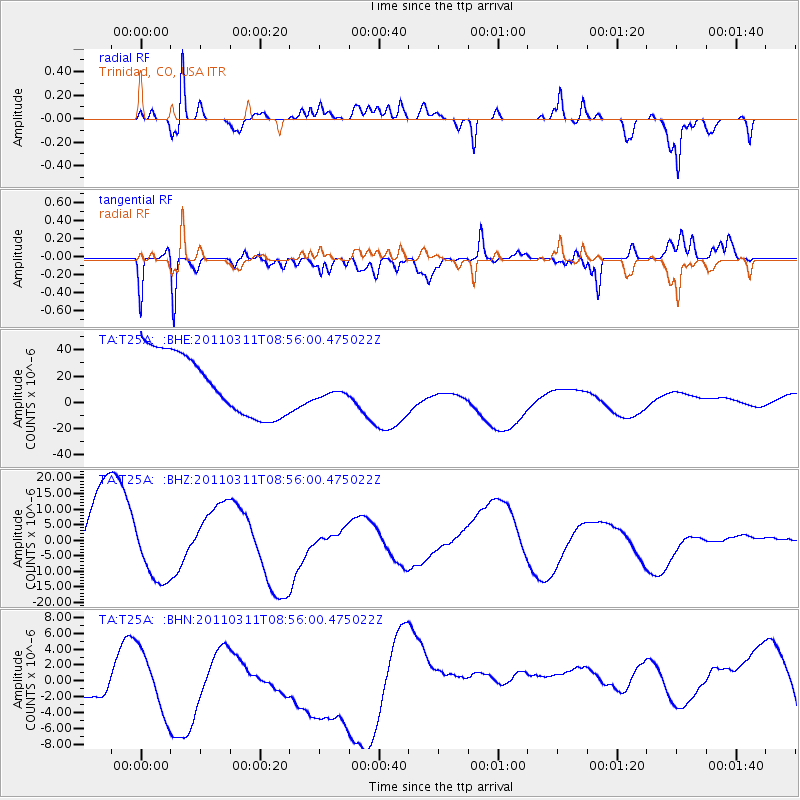
T25A Trinidad, CO, USA - Earthquake Result Viewer
*The percent match for this event was below the threshold and hence no stack was calculated.
| Earthquake location: |
Near East Coast Of Honshu, Japan |
| Earthquake latitude/longitude: |
36.1/141.0 |
| Earthquake time(UTC): |
2011/03/11 (070) 08:44:00 GMT |
| Earthquake Depth: |
47 km |
| Earthquake Magnitude: |
5.6 MB |
| Earthquake Catalog/Contributor: |
WHDF/NEIC |
|
| Network: |
TA USArray Transportable Network (new EarthScope stations) |
| Station: |
T25A Trinidad, CO, USA |
| Lat/Lon: |
37.14 N/104.41 W |
| Elevation: |
2017 m |
|
| Distance: |
85.2 deg |
| Az: |
46.802 deg |
| Baz: |
312.389 deg |
| Ray Param: |
$rayparam |
*The percent match for this event was below the threshold and hence was not used in the summary stack. |
|
| Radial Match: |
50.94986 % |
| Radial Bump: |
400 |
| Transverse Match: |
32.718643 % |
| Transverse Bump: |
357 |
| SOD ConfigId: |
356183 |
| Insert Time: |
2011-08-13 23:22:42.941 +0000 |
| GWidth: |
2.5 |
| Max Bumps: |
400 |
| Tol: |
0.001 |
|
Signal To Noise
| Channel | StoN | STA | LTA |
| TA:T25A: :BHZ:20110311T08:56:00.475022Z | 0.89188194 | 9.891865E-6 | 1.1091003E-5 |
| TA:T25A: :BHN:20110311T08:56:00.475022Z | 0.6747344 | 5.6237236E-6 | 8.334722E-6 |
| TA:T25A: :BHE:20110311T08:56:00.475022Z | 0.32138544 | 7.505005E-6 | 2.3352037E-5 |
| Arrivals |
| Ps | |
| PpPs | |
| PsPs/PpSs | |


