You are here: Home > Network List > TA - USArray Transportable Network (new EarthScope stations) Stations List
> Station Q29A Oakley, KS, USA > Earthquake Result Viewer
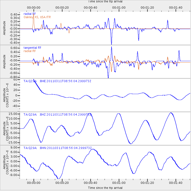
Q29A Oakley, KS, USA - Earthquake Result Viewer
*The percent match for this event was below the threshold and hence no stack was calculated.
| Earthquake location: |
Near East Coast Of Honshu, Japan |
| Earthquake latitude/longitude: |
36.1/141.0 |
| Earthquake time(UTC): |
2011/03/11 (070) 08:44:00 GMT |
| Earthquake Depth: |
47 km |
| Earthquake Magnitude: |
5.6 MB |
| Earthquake Catalog/Contributor: |
WHDF/NEIC |
|
| Network: |
TA USArray Transportable Network (new EarthScope stations) |
| Station: |
Q29A Oakley, KS, USA |
| Lat/Lon: |
38.89 N/100.98 W |
| Elevation: |
895 m |
|
| Distance: |
86.0 deg |
| Az: |
43.661 deg |
| Baz: |
314.254 deg |
| Ray Param: |
$rayparam |
*The percent match for this event was below the threshold and hence was not used in the summary stack. |
|
| Radial Match: |
42.752922 % |
| Radial Bump: |
400 |
| Transverse Match: |
48.131977 % |
| Transverse Bump: |
400 |
| SOD ConfigId: |
356183 |
| Insert Time: |
2011-08-13 23:25:31.683 +0000 |
| GWidth: |
2.5 |
| Max Bumps: |
400 |
| Tol: |
0.001 |
|
Signal To Noise
| Channel | StoN | STA | LTA |
| TA:Q29A: :BHZ:20110311T08:56:04.299973Z | 1.4739921 | 7.846812E-6 | 5.32351E-6 |
| TA:Q29A: :BHN:20110311T08:56:04.299973Z | 2.3587625 | 1.1580814E-5 | 4.909699E-6 |
| TA:Q29A: :BHE:20110311T08:56:04.299973Z | 1.2184211 | 2.022616E-5 | 1.6600303E-5 |
| Arrivals |
| Ps | |
| PpPs | |
| PsPs/PpSs | |


