You are here: Home > Network List > TA - USArray Transportable Network (new EarthScope stations) Stations List
> Station V34A Guthrie, OK, USA > Earthquake Result Viewer
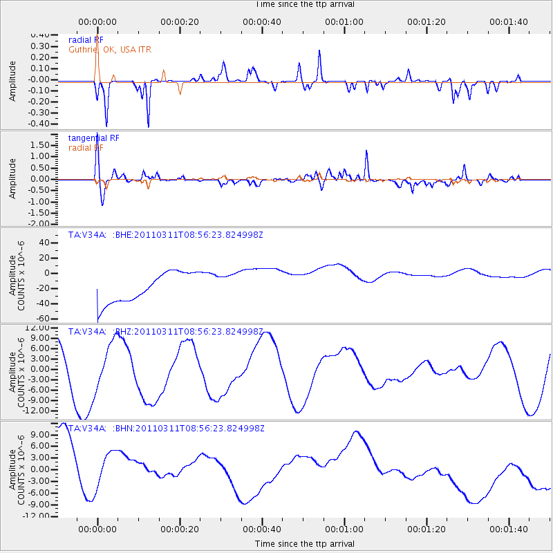
V34A Guthrie, OK, USA - Earthquake Result Viewer
*The percent match for this event was below the threshold and hence no stack was calculated.
| Earthquake location: |
Near East Coast Of Honshu, Japan |
| Earthquake latitude/longitude: |
36.1/141.0 |
| Earthquake time(UTC): |
2011/03/11 (070) 08:44:00 GMT |
| Earthquake Depth: |
47 km |
| Earthquake Magnitude: |
5.6 MB |
| Earthquake Catalog/Contributor: |
WHDF/NEIC |
|
| Network: |
TA USArray Transportable Network (new EarthScope stations) |
| Station: |
V34A Guthrie, OK, USA |
| Lat/Lon: |
35.83 N/97.52 W |
| Elevation: |
329 m |
|
| Distance: |
90.1 deg |
| Az: |
43.845 deg |
| Baz: |
316.353 deg |
| Ray Param: |
$rayparam |
*The percent match for this event was below the threshold and hence was not used in the summary stack. |
|
| Radial Match: |
44.96072 % |
| Radial Bump: |
166 |
| Transverse Match: |
45.0304 % |
| Transverse Bump: |
400 |
| SOD ConfigId: |
356183 |
| Insert Time: |
2011-08-13 23:36:27.565 +0000 |
| GWidth: |
2.5 |
| Max Bumps: |
400 |
| Tol: |
0.001 |
|
Signal To Noise
| Channel | StoN | STA | LTA |
| TA:V34A: :BHZ:20110311T08:56:23.824998Z | 1.4708116 | 6.4324377E-6 | 4.373393E-6 |
| TA:V34A: :BHN:20110311T08:56:23.824998Z | 0.67474383 | 9.278623E-6 | 1.3751327E-5 |
| TA:V34A: :BHE:20110311T08:56:23.824998Z | 0.87661994 | 1.7125736E-5 | 1.95361E-5 |
| Arrivals |
| Ps | |
| PpPs | |
| PsPs/PpSs | |


