You are here: Home > Network List > TA - USArray Transportable Network (new EarthScope stations) Stations List
> Station N35A Tabor, IA, USA > Earthquake Result Viewer
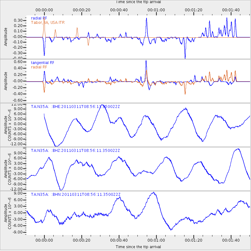
N35A Tabor, IA, USA - Earthquake Result Viewer
*The percent match for this event was below the threshold and hence no stack was calculated.
| Earthquake location: |
Near East Coast Of Honshu, Japan |
| Earthquake latitude/longitude: |
36.1/141.0 |
| Earthquake time(UTC): |
2011/03/11 (070) 08:44:00 GMT |
| Earthquake Depth: |
47 km |
| Earthquake Magnitude: |
5.6 MB |
| Earthquake Catalog/Contributor: |
WHDF/NEIC |
|
| Network: |
TA USArray Transportable Network (new EarthScope stations) |
| Station: |
N35A Tabor, IA, USA |
| Lat/Lon: |
40.86 N/95.64 W |
| Elevation: |
353 m |
|
| Distance: |
87.4 deg |
| Az: |
39.338 deg |
| Baz: |
317.416 deg |
| Ray Param: |
$rayparam |
*The percent match for this event was below the threshold and hence was not used in the summary stack. |
|
| Radial Match: |
65.956955 % |
| Radial Bump: |
292 |
| Transverse Match: |
53.013584 % |
| Transverse Bump: |
301 |
| SOD ConfigId: |
356183 |
| Insert Time: |
2011-08-13 23:43:39.870 +0000 |
| GWidth: |
2.5 |
| Max Bumps: |
400 |
| Tol: |
0.001 |
|
Signal To Noise
| Channel | StoN | STA | LTA |
| TA:N35A: :BHZ:20110311T08:56:11.350022Z | 0.7142739 | 4.378148E-6 | 6.129508E-6 |
| TA:N35A: :BHN:20110311T08:56:11.350022Z | 0.77608275 | 3.9595625E-6 | 5.1019847E-6 |
| TA:N35A: :BHE:20110311T08:56:11.350022Z | 2.5856454 | 1.3663345E-5 | 5.284307E-6 |
| Arrivals |
| Ps | |
| PpPs | |
| PsPs/PpSs | |


