You are here: Home > Network List > TA - USArray Transportable Network (new EarthScope stations) Stations List
> Station O33A Hebron, NE, USA > Earthquake Result Viewer
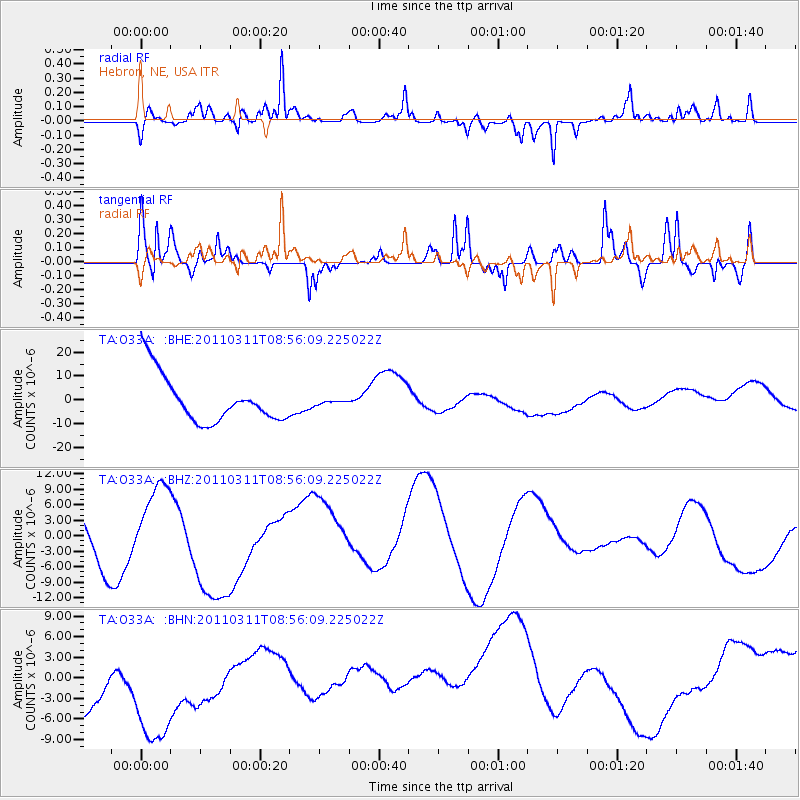
O33A Hebron, NE, USA - Earthquake Result Viewer
*The percent match for this event was below the threshold and hence no stack was calculated.
| Earthquake location: |
Near East Coast Of Honshu, Japan |
| Earthquake latitude/longitude: |
36.1/141.0 |
| Earthquake time(UTC): |
2011/03/11 (070) 08:44:00 GMT |
| Earthquake Depth: |
47 km |
| Earthquake Magnitude: |
5.6 MB |
| Earthquake Catalog/Contributor: |
WHDF/NEIC |
|
| Network: |
TA USArray Transportable Network (new EarthScope stations) |
| Station: |
O33A Hebron, NE, USA |
| Lat/Lon: |
40.08 N/97.58 W |
| Elevation: |
480 m |
|
| Distance: |
87.0 deg |
| Az: |
40.957 deg |
| Baz: |
316.239 deg |
| Ray Param: |
$rayparam |
*The percent match for this event was below the threshold and hence was not used in the summary stack. |
|
| Radial Match: |
65.070465 % |
| Radial Bump: |
384 |
| Transverse Match: |
47.384727 % |
| Transverse Bump: |
400 |
| SOD ConfigId: |
356183 |
| Insert Time: |
2011-08-13 23:44:30.965 +0000 |
| GWidth: |
2.5 |
| Max Bumps: |
400 |
| Tol: |
0.001 |
|
Signal To Noise
| Channel | StoN | STA | LTA |
| TA:O33A: :BHZ:20110311T08:56:09.225022Z | 1.7722055 | 7.643905E-6 | 4.313216E-6 |
| TA:O33A: :BHN:20110311T08:56:09.225022Z | 1.3355992 | 1.3481387E-5 | 1.0093888E-5 |
| TA:O33A: :BHE:20110311T08:56:09.225022Z | 0.06898467 | 6.8581267E-7 | 9.941523E-6 |
| Arrivals |
| Ps | |
| PpPs | |
| PsPs/PpSs | |


