You are here: Home > Network List > AZ - ANZA Regional Network Stations List
> Station LVA2 AZ.LVA2 > Earthquake Result Viewer
LVA2 AZ.LVA2 - Earthquake Result Viewer
| Earthquake location: |
Mariana Islands |
| Earthquake latitude/longitude: |
19.3/145.6 |
| Earthquake time(UTC): |
1999/06/23 (174) 19:37:22 GMT |
| Earthquake Depth: |
103 km |
| Earthquake Magnitude: |
5.5 MB, 4.9 MS |
| Earthquake Catalog/Contributor: |
WHDF/NEIC |
|
| Network: |
AZ ANZA Regional Network |
| Station: |
LVA2 AZ.LVA2 |
| Lat/Lon: |
33.35 N/116.56 W |
| Elevation: |
1435 m |
|
| Distance: |
85.9 deg |
| Az: |
56.228 deg |
| Baz: |
290.261 deg |
| Ray Param: |
0.04421551 |
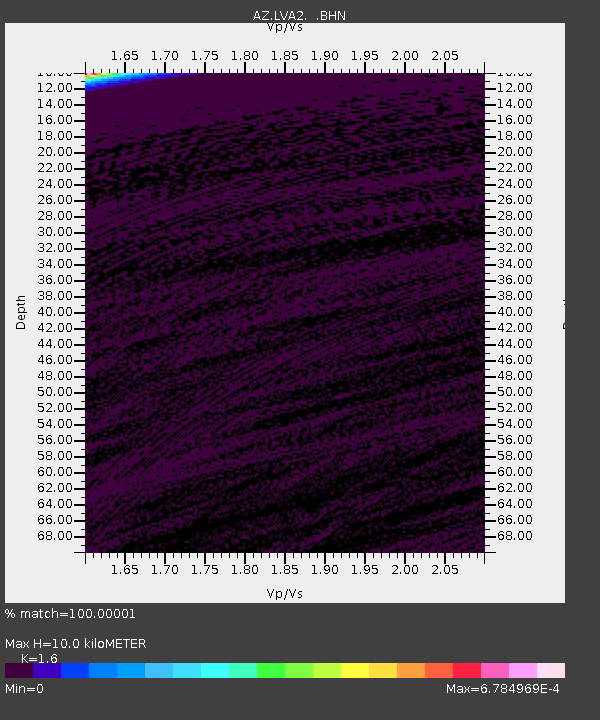
| Estimated Moho Depth: |
10.0 km |
| Estimated Crust Vp/Vs: |
1.60 |
| Assumed Crust Vp: |
6.264 km/s |
| Estimated Crust Vs: |
3.915 km/s |
| Estimated Crust Poisson's Ratio: |
0.18 |
|
| Radial Match: |
100.00001 % |
| Radial Bump: |
2 |
| Transverse Match: |
100.0 % |
| Transverse Bump: |
2 |
| SOD ConfigId: |
32974 |
| Insert Time: |
2010-02-26 19:49:42.021 +0000 |
| GWidth: |
2.5 |
| Max Bumps: |
400 |
| Tol: |
0.001 |
|
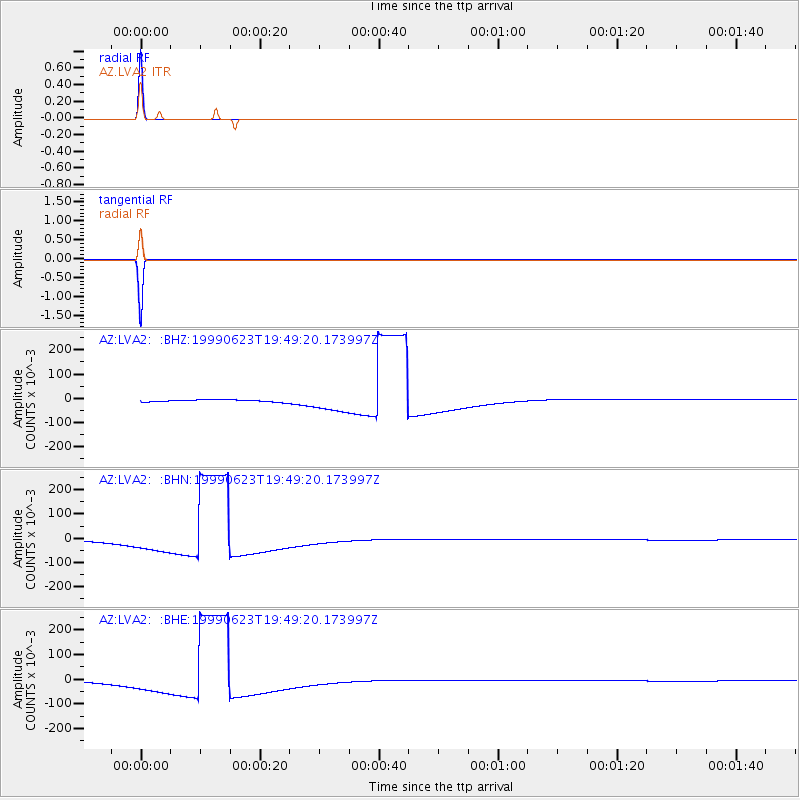
Signal To Noise
| Channel | StoN | STA | LTA |
| AZ:LVA2: :BHN:19990623T19:49:20.173997Z | 9.038968 | 0.038119473 | 0.0042172372 |
| AZ:LVA2: :BHE:19990623T19:49:20.173997Z | 9.038407 | 0.038118366 | 0.0042173765 |
| AZ:LVA2: :BHZ:19990623T19:49:20.173997Z | 9.03867 | 0.0381192 | 0.004217346 |
| Arrivals |
| Ps | 1.0 SECOND |
| PpPs | 4.0 SECOND |
| PsPs/PpSs | 5.0 SECOND |


