You are here: Home > Network List > US - United States National Seismic Network Stations List
> Station ERPA Erie, Pennsylvania, USA > Earthquake Result Viewer
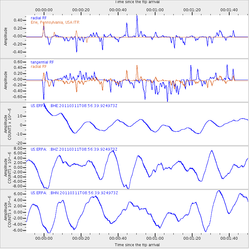
ERPA Erie, Pennsylvania, USA - Earthquake Result Viewer
*The percent match for this event was below the threshold and hence no stack was calculated.
| Earthquake location: |
Near East Coast Of Honshu, Japan |
| Earthquake latitude/longitude: |
36.1/141.0 |
| Earthquake time(UTC): |
2011/03/11 (070) 08:44:00 GMT |
| Earthquake Depth: |
47 km |
| Earthquake Magnitude: |
5.6 MB |
| Earthquake Catalog/Contributor: |
WHDF/NEIC |
|
| Network: |
US United States National Seismic Network |
| Station: |
ERPA Erie, Pennsylvania, USA |
| Lat/Lon: |
42.12 N/79.99 W |
| Elevation: |
306 m |
|
| Distance: |
93.6 deg |
| Az: |
29.251 deg |
| Baz: |
327.877 deg |
| Ray Param: |
$rayparam |
*The percent match for this event was below the threshold and hence was not used in the summary stack. |
|
| Radial Match: |
69.83613 % |
| Radial Bump: |
282 |
| Transverse Match: |
60.32999 % |
| Transverse Bump: |
290 |
| SOD ConfigId: |
356183 |
| Insert Time: |
2011-08-14 00:03:27.833 +0000 |
| GWidth: |
2.5 |
| Max Bumps: |
400 |
| Tol: |
0.001 |
|
Signal To Noise
| Channel | StoN | STA | LTA |
| US:ERPA: :BHZ:20110311T08:56:39.924973Z | 3.511073 | 7.823958E-6 | 2.2283666E-6 |
| US:ERPA: :BHN:20110311T08:56:39.924973Z | 1.2711864 | 9.30636E-6 | 7.321004E-6 |
| US:ERPA: :BHE:20110311T08:56:39.924973Z | 1.250542 | 1.0486376E-5 | 8.385465E-6 |
| Arrivals |
| Ps | |
| PpPs | |
| PsPs/PpSs | |


