You are here: Home > Network List > US - United States National Seismic Network Stations List
> Station EGMT Eagleton, Montana, USA > Earthquake Result Viewer
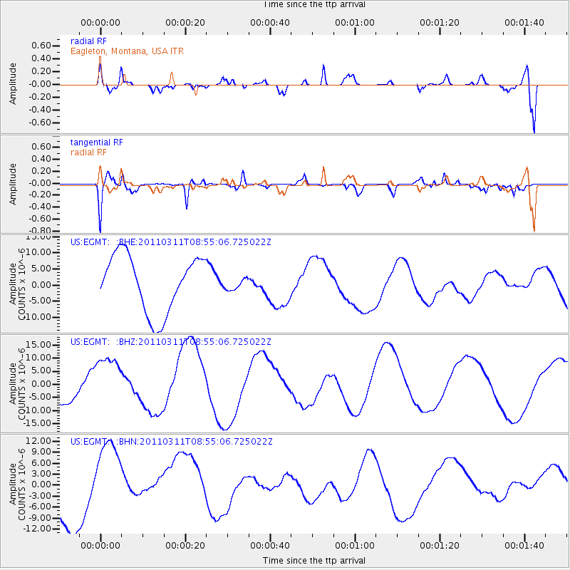
EGMT Eagleton, Montana, USA - Earthquake Result Viewer
*The percent match for this event was below the threshold and hence no stack was calculated.
| Earthquake location: |
Near East Coast Of Honshu, Japan |
| Earthquake latitude/longitude: |
36.1/141.0 |
| Earthquake time(UTC): |
2011/03/11 (070) 08:44:00 GMT |
| Earthquake Depth: |
47 km |
| Earthquake Magnitude: |
5.6 MB |
| Earthquake Catalog/Contributor: |
WHDF/NEIC |
|
| Network: |
US United States National Seismic Network |
| Station: |
EGMT Eagleton, Montana, USA |
| Lat/Lon: |
48.02 N/109.75 W |
| Elevation: |
1055 m |
|
| Distance: |
75.2 deg |
| Az: |
40.951 deg |
| Baz: |
307.769 deg |
| Ray Param: |
$rayparam |
*The percent match for this event was below the threshold and hence was not used in the summary stack. |
|
| Radial Match: |
65.35607 % |
| Radial Bump: |
400 |
| Transverse Match: |
60.46884 % |
| Transverse Bump: |
347 |
| SOD ConfigId: |
356183 |
| Insert Time: |
2011-08-14 00:04:05.434 +0000 |
| GWidth: |
2.5 |
| Max Bumps: |
400 |
| Tol: |
0.001 |
|
Signal To Noise
| Channel | StoN | STA | LTA |
| US:EGMT: :BHZ:20110311T08:55:06.725022Z | 2.5050757 | 1.082851E-5 | 4.322628E-6 |
| US:EGMT: :BHN:20110311T08:55:06.725022Z | 1.9449146 | 1.2195638E-5 | 6.2705262E-6 |
| US:EGMT: :BHE:20110311T08:55:06.725022Z | 0.21151192 | 1.8498833E-6 | 8.746E-6 |
| Arrivals |
| Ps | |
| PpPs | |
| PsPs/PpSs | |


