You are here: Home > Network List > TA - USArray Transportable Network (new EarthScope stations) Stations List
> Station R11A Troy Canyon, Currant, NV, USA > Earthquake Result Viewer
R11A Troy Canyon, Currant, NV, USA - Earthquake Result Viewer
*The percent match for this event was below the threshold and hence no stack was calculated.
| Earthquake location: |
Off East Coast Of Honshu, Japan |
| Earthquake latitude/longitude: |
37.4/142.5 |
| Earthquake time(UTC): |
2011/03/11 (070) 08:46:45 GMT |
| Earthquake Depth: |
26 km |
| Earthquake Magnitude: |
5.6 MB |
| Earthquake Catalog/Contributor: |
WHDF/NEIC |
|
| Network: |
TA USArray Transportable Network (new EarthScope stations) |
| Station: |
R11A Troy Canyon, Currant, NV, USA |
| Lat/Lon: |
38.35 N/115.59 W |
| Elevation: |
1756 m |
|
| Distance: |
75.9 deg |
| Az: |
52.483 deg |
| Baz: |
306.563 deg |
| Ray Param: |
$rayparam |
*The percent match for this event was below the threshold and hence was not used in the summary stack. |
|
| Radial Match: |
71.91719 % |
| Radial Bump: |
227 |
| Transverse Match: |
56.968506 % |
| Transverse Bump: |
276 |
| SOD ConfigId: |
356183 |
| Insert Time: |
2011-08-14 00:49:22.324 +0000 |
| GWidth: |
2.5 |
| Max Bumps: |
400 |
| Tol: |
0.001 |
|
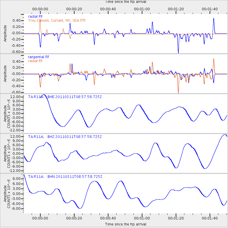
Signal To Noise
| Channel | StoN | STA | LTA |
| TA:R11A: :BHZ:20110311T08:57:58.725Z | 1.9850178 | 7.918632E-6 | 3.9891997E-6 |
| TA:R11A: :BHN:20110311T08:57:58.725Z | 0.26332107 | 2.026104E-6 | 7.694424E-6 |
| TA:R11A: :BHE:20110311T08:57:58.725Z | 0.8172953 | 6.04817E-6 | 7.400226E-6 |
| Arrivals |
| Ps | |
| PpPs | |
| PsPs/PpSs | |


