You are here: Home > Network List > TA - USArray Transportable Network (new EarthScope stations) Stations List
> Station R32A Long Quarter, Great Bend, KS, USA > Earthquake Result Viewer
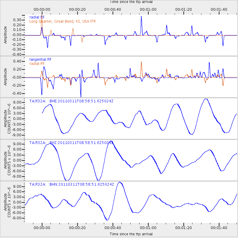
R32A Long Quarter, Great Bend, KS, USA - Earthquake Result Viewer
*The percent match for this event was below the threshold and hence no stack was calculated.
| Earthquake location: |
Off East Coast Of Honshu, Japan |
| Earthquake latitude/longitude: |
37.4/142.5 |
| Earthquake time(UTC): |
2011/03/11 (070) 08:46:45 GMT |
| Earthquake Depth: |
26 km |
| Earthquake Magnitude: |
5.6 MB |
| Earthquake Catalog/Contributor: |
WHDF/NEIC |
|
| Network: |
TA USArray Transportable Network (new EarthScope stations) |
| Station: |
R32A Long Quarter, Great Bend, KS, USA |
| Lat/Lon: |
38.42 N/98.71 W |
| Elevation: |
573 m |
|
| Distance: |
85.8 deg |
| Az: |
43.622 deg |
| Baz: |
315.627 deg |
| Ray Param: |
$rayparam |
*The percent match for this event was below the threshold and hence was not used in the summary stack. |
|
| Radial Match: |
59.237522 % |
| Radial Bump: |
257 |
| Transverse Match: |
68.879074 % |
| Transverse Bump: |
267 |
| SOD ConfigId: |
356183 |
| Insert Time: |
2011-08-14 00:58:08.926 +0000 |
| GWidth: |
2.5 |
| Max Bumps: |
400 |
| Tol: |
0.001 |
|
Signal To Noise
| Channel | StoN | STA | LTA |
| TA:R32A: :BHZ:20110311T08:58:51.625024Z | 2.4311967 | 9.287848E-6 | 3.8202784E-6 |
| TA:R32A: :BHN:20110311T08:58:51.625024Z | 1.9430239 | 5.75513E-6 | 2.961945E-6 |
| TA:R32A: :BHE:20110311T08:58:51.625024Z | 0.60679144 | 3.1485654E-6 | 5.1888755E-6 |
| Arrivals |
| Ps | |
| PpPs | |
| PsPs/PpSs | |


