You are here: Home > Network List > TA - USArray Transportable Network (new EarthScope stations) Stations List
> Station M37A Trindle Farm, Earlham, IA, USA > Earthquake Result Viewer
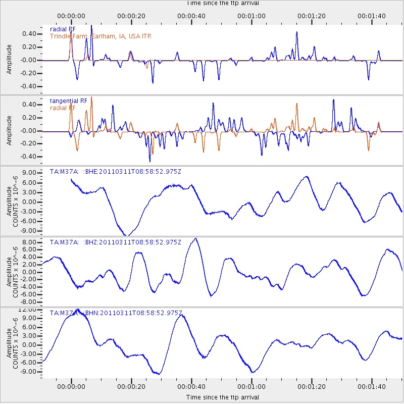
M37A Trindle Farm, Earlham, IA, USA - Earthquake Result Viewer
*The percent match for this event was below the threshold and hence no stack was calculated.
| Earthquake location: |
Off East Coast Of Honshu, Japan |
| Earthquake latitude/longitude: |
37.4/142.5 |
| Earthquake time(UTC): |
2011/03/11 (070) 08:46:45 GMT |
| Earthquake Depth: |
26 km |
| Earthquake Magnitude: |
5.6 MB |
| Earthquake Catalog/Contributor: |
WHDF/NEIC |
|
| Network: |
TA USArray Transportable Network (new EarthScope stations) |
| Station: |
M37A Trindle Farm, Earlham, IA, USA |
| Lat/Lon: |
41.40 N/94.06 W |
| Elevation: |
325 m |
|
| Distance: |
86.1 deg |
| Az: |
38.964 deg |
| Baz: |
318.275 deg |
| Ray Param: |
$rayparam |
*The percent match for this event was below the threshold and hence was not used in the summary stack. |
|
| Radial Match: |
35.583046 % |
| Radial Bump: |
202 |
| Transverse Match: |
51.26927 % |
| Transverse Bump: |
177 |
| SOD ConfigId: |
356183 |
| Insert Time: |
2011-08-14 01:16:51.129 +0000 |
| GWidth: |
2.5 |
| Max Bumps: |
400 |
| Tol: |
0.001 |
|
Signal To Noise
| Channel | StoN | STA | LTA |
| TA:M37A: :BHZ:20110311T08:58:52.975Z | 1.2518994 | 4.57985E-6 | 3.658321E-6 |
| TA:M37A: :BHN:20110311T08:58:52.975Z | 6.1657434 | 1.6680639E-5 | 2.7053734E-6 |
| TA:M37A: :BHE:20110311T08:58:52.975Z | 0.98643726 | 5.6528916E-6 | 5.7306147E-6 |
| Arrivals |
| Ps | |
| PpPs | |
| PsPs/PpSs | |


