You are here: Home > Network List > TA - USArray Transportable Network (new EarthScope stations) Stations List
> Station O37A Wolven Farm, McFall, MO, USA > Earthquake Result Viewer
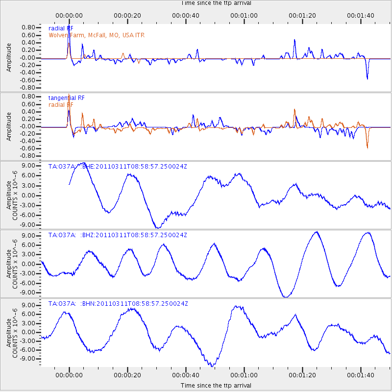
O37A Wolven Farm, McFall, MO, USA - Earthquake Result Viewer
*The percent match for this event was below the threshold and hence no stack was calculated.
| Earthquake location: |
Off East Coast Of Honshu, Japan |
| Earthquake latitude/longitude: |
37.4/142.5 |
| Earthquake time(UTC): |
2011/03/11 (070) 08:46:45 GMT |
| Earthquake Depth: |
26 km |
| Earthquake Magnitude: |
5.6 MB |
| Earthquake Catalog/Contributor: |
WHDF/NEIC |
|
| Network: |
TA USArray Transportable Network (new EarthScope stations) |
| Station: |
O37A Wolven Farm, McFall, MO, USA |
| Lat/Lon: |
40.17 N/94.15 W |
| Elevation: |
284 m |
|
| Distance: |
87.0 deg |
| Az: |
39.838 deg |
| Baz: |
318.27 deg |
| Ray Param: |
$rayparam |
*The percent match for this event was below the threshold and hence was not used in the summary stack. |
|
| Radial Match: |
55.19935 % |
| Radial Bump: |
269 |
| Transverse Match: |
66.139496 % |
| Transverse Bump: |
198 |
| SOD ConfigId: |
356183 |
| Insert Time: |
2011-08-14 01:17:41.905 +0000 |
| GWidth: |
2.5 |
| Max Bumps: |
400 |
| Tol: |
0.001 |
|
Signal To Noise
| Channel | StoN | STA | LTA |
| TA:O37A: :BHZ:20110311T08:58:57.250024Z | 0.49778044 | 1.99243E-6 | 4.0026284E-6 |
| TA:O37A: :BHN:20110311T08:58:57.250024Z | 0.8935675 | 5.4270513E-6 | 6.073465E-6 |
| TA:O37A: :BHE:20110311T08:58:57.250024Z | 2.4014475 | 1.133022E-5 | 4.7180793E-6 |
| Arrivals |
| Ps | |
| PpPs | |
| PsPs/PpSs | |


