You are here: Home > Network List > TA - USArray Transportable Network (new EarthScope stations) Stations List
> Station U39A Green Forest, AR, USA > Earthquake Result Viewer
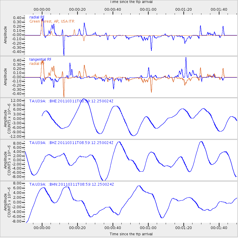
U39A Green Forest, AR, USA - Earthquake Result Viewer

| Earthquake location: |
Off East Coast Of Honshu, Japan |
| Earthquake latitude/longitude: |
37.4/142.5 |
| Earthquake time(UTC): |
2011/03/11 (070) 08:46:45 GMT |
| Earthquake Depth: |
26 km |
| Earthquake Magnitude: |
5.6 MB |
| Earthquake Catalog/Contributor: |
WHDF/NEIC |
|
| Network: |
TA USArray Transportable Network (new EarthScope stations) |
| Station: |
U39A Green Forest, AR, USA |
| Lat/Lon: |
36.38 N/93.48 W |
| Elevation: |
433 m |
|
| Distance: |
90.1 deg |
| Az: |
41.949 deg |
| Baz: |
318.734 deg |
| Ray Param: |
0.041691285 |
| Estimated Moho Depth: |
52.25 km |
| Estimated Crust Vp/Vs: |
1.69 |
| Assumed Crust Vp: |
6.53 km/s |
| Estimated Crust Vs: |
3.876 km/s |
| Estimated Crust Poisson's Ratio: |
0.23 |
|
| Radial Match: |
81.780396 % |
| Radial Bump: |
297 |
| Transverse Match: |
51.35454 % |
| Transverse Bump: |
225 |
| SOD ConfigId: |
356183 |
| Insert Time: |
2011-08-14 01:18:51.826 +0000 |
| GWidth: |
2.5 |
| Max Bumps: |
400 |
| Tol: |
0.001 |
|
Signal To Noise
| Channel | StoN | STA | LTA |
| TA:U39A: :BHZ:20110311T08:59:12.250024Z | 0.23276618 | 1.9370782E-6 | 8.321991E-6 |
| TA:U39A: :BHN:20110311T08:59:12.250024Z | 1.6761945 | 7.984373E-6 | 4.7633926E-6 |
| TA:U39A: :BHE:20110311T08:59:12.250024Z | 1.5430144 | 9.408603E-6 | 6.0975462E-6 |
| Arrivals |
| Ps | 5.6 SECOND |
| PpPs | 21 SECOND |
| PsPs/PpSs | 27 SECOND |


