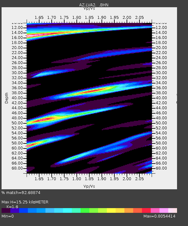
LVA2 AZ.LVA2 - Earthquake Result Viewer
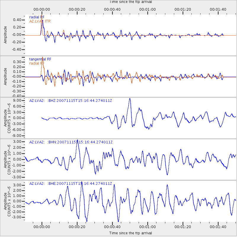
Earthquake location: Near Coast Of Northern Chile
Earthquake latitude/longitude: -22.9/-70.2
Earthquake time(UTC): 2007/11/15 (319) 15:05:58 GMT
Earthquake Depth: 26 km
Earthquake Magnitude: 6.1 MB, 6.6 MS, 6.8 MW, 6.6 MW
Earthquake Catalog/Contributor: WHDF/NEIC
Network: AZ ANZA Regional Network
Station: LVA2 AZ.LVA2
Lat/Lon: 33.35 N/116.56 W
Elevation: 1435 m
Distance: 71.3 deg
Az: 320.269 deg
Baz: 135.246 deg
Ray Param: 0.054400794
Estimated Moho Depth: 15.25 km
Estimated Crust Vp/Vs: 1.60
Assumed Crust Vp: 6.264 km/s
Estimated Crust Vs: 3.915 km/s
Estimated Crust Poisson's Ratio: 0.18
Radial Match: 92.68874 %
Radial Bump: 400
Transverse Match: 82.67153 %
Transverse Bump: 400
SOD ConfigId: 2564
Insert Time: 2010-02-26 19:50:14.212 +0000
GWidth: 2.5
Max Bumps: 400
Tol: 0.001

Signal To Noise

ChannelStoNSTALTA
AZ:LVA2: :BHN:20071115T15:16:44.274011Z0.50600352.0194074E-73.9908957E-7
AZ:LVA2: :BHE:20071115T15:16:44.274011Z0.879898253.5595423E-74.045402E-7
AZ:LVA2: :BHZ:20071115T15:16:44.274011Z0.946549652.580963E-72.726706E-7
Arrivals
Ps1.5 SECOND
PpPs6.1 SECOND
PsPs/PpSs7.6 SECOND