You are here: Home > Network List > IC - New China Digital Seismograph Network Stations List
> Station KMI Kunming, Yunnan Province, China > Earthquake Result Viewer
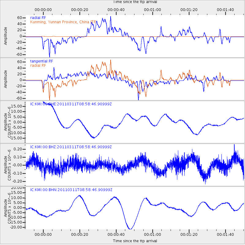
KMI Kunming, Yunnan Province, China - Earthquake Result Viewer
*The percent match for this event was below the threshold and hence no stack was calculated.
| Earthquake location: |
Near East Coast Of Honshu, Japan |
| Earthquake latitude/longitude: |
36.8/141.9 |
| Earthquake time(UTC): |
2011/03/11 (070) 08:52:23 GMT |
| Earthquake Depth: |
17 km |
| Earthquake Magnitude: |
5.5 MB |
| Earthquake Catalog/Contributor: |
WHDF/NEIC |
|
| Network: |
IC New China Digital Seismograph Network |
| Station: |
KMI Kunming, Yunnan Province, China |
| Lat/Lon: |
25.12 N/102.74 E |
| Elevation: |
1975 m |
|
| Distance: |
35.3 deg |
| Az: |
262.073 deg |
| Baz: |
61.323 deg |
| Ray Param: |
$rayparam |
*The percent match for this event was below the threshold and hence was not used in the summary stack. |
|
| Radial Match: |
49.236225 % |
| Radial Bump: |
400 |
| Transverse Match: |
45.02676 % |
| Transverse Bump: |
400 |
| SOD ConfigId: |
356183 |
| Insert Time: |
2011-08-14 02:00:43.676 +0000 |
| GWidth: |
2.5 |
| Max Bumps: |
400 |
| Tol: |
0.001 |
|
Signal To Noise
| Channel | StoN | STA | LTA |
| IC:KMI:00:BHZ:20110311T08:58:46.90999Z | 1.1679327 | 6.138873E-8 | 5.2561873E-8 |
| IC:KMI:00:BHN:20110311T08:58:46.90999Z | 2.1259806 | 1.46707325E-5 | 6.900689E-6 |
| IC:KMI:00:BHE:20110311T08:58:46.90999Z | 1.3219515 | 1.1344978E-5 | 8.581992E-6 |
| Arrivals |
| Ps | |
| PpPs | |
| PsPs/PpSs | |


