You are here: Home > Network List > TA - USArray Transportable Network (new EarthScope stations) Stations List
> Station C26A Wahner Farm, Parshall, ND, USA > Earthquake Result Viewer
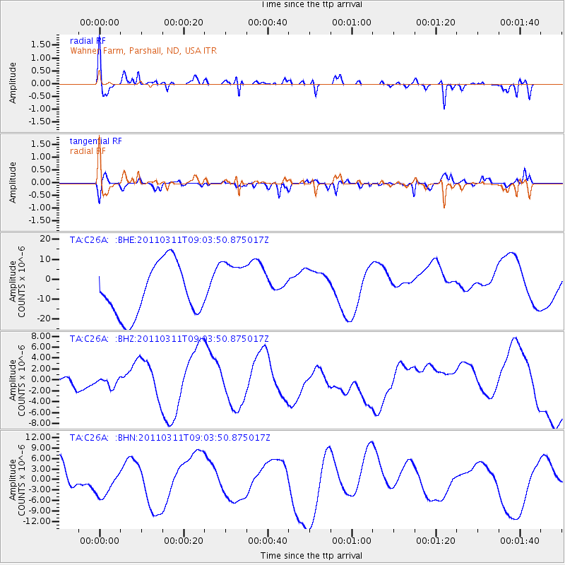
C26A Wahner Farm, Parshall, ND, USA - Earthquake Result Viewer
*The percent match for this event was below the threshold and hence no stack was calculated.
| Earthquake location: |
Near East Coast Of Honshu, Japan |
| Earthquake latitude/longitude: |
36.8/141.9 |
| Earthquake time(UTC): |
2011/03/11 (070) 08:52:23 GMT |
| Earthquake Depth: |
17 km |
| Earthquake Magnitude: |
5.5 MB |
| Earthquake Catalog/Contributor: |
WHDF/NEIC |
|
| Network: |
TA USArray Transportable Network (new EarthScope stations) |
| Station: |
C26A Wahner Farm, Parshall, ND, USA |
| Lat/Lon: |
47.83 N/102.10 W |
| Elevation: |
656 m |
|
| Distance: |
78.3 deg |
| Az: |
38.22 deg |
| Baz: |
312.504 deg |
| Ray Param: |
$rayparam |
*The percent match for this event was below the threshold and hence was not used in the summary stack. |
|
| Radial Match: |
48.152435 % |
| Radial Bump: |
400 |
| Transverse Match: |
42.350433 % |
| Transverse Bump: |
400 |
| SOD ConfigId: |
356183 |
| Insert Time: |
2011-08-14 02:26:22.122 +0000 |
| GWidth: |
2.5 |
| Max Bumps: |
400 |
| Tol: |
0.001 |
|
Signal To Noise
| Channel | StoN | STA | LTA |
| TA:C26A: :BHZ:20110311T09:03:50.875017Z | 0.24746072 | 7.898167E-7 | 3.191685E-6 |
| TA:C26A: :BHN:20110311T09:03:50.875017Z | 0.743868 | 3.9726806E-6 | 5.340572E-6 |
| TA:C26A: :BHE:20110311T09:03:50.875017Z | 1.074699 | 1.36530225E-5 | 1.2704042E-5 |
| Arrivals |
| Ps | |
| PpPs | |
| PsPs/PpSs | |


