You are here: Home > Network List > TA - USArray Transportable Network (new EarthScope stations) Stations List
> Station B27A Peters Farms, Glenburn, ND, USA > Earthquake Result Viewer
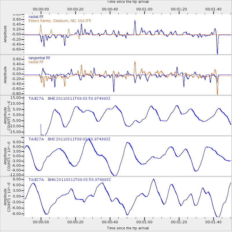
B27A Peters Farms, Glenburn, ND, USA - Earthquake Result Viewer
*The percent match for this event was below the threshold and hence no stack was calculated.
| Earthquake location: |
Near East Coast Of Honshu, Japan |
| Earthquake latitude/longitude: |
36.8/141.9 |
| Earthquake time(UTC): |
2011/03/11 (070) 08:52:23 GMT |
| Earthquake Depth: |
17 km |
| Earthquake Magnitude: |
5.5 MB |
| Earthquake Catalog/Contributor: |
WHDF/NEIC |
|
| Network: |
TA USArray Transportable Network (new EarthScope stations) |
| Station: |
B27A Peters Farms, Glenburn, ND, USA |
| Lat/Lon: |
48.40 N/101.26 W |
| Elevation: |
492 m |
|
| Distance: |
78.3 deg |
| Az: |
37.398 deg |
| Baz: |
312.958 deg |
| Ray Param: |
$rayparam |
*The percent match for this event was below the threshold and hence was not used in the summary stack. |
|
| Radial Match: |
73.187584 % |
| Radial Bump: |
400 |
| Transverse Match: |
68.18397 % |
| Transverse Bump: |
400 |
| SOD ConfigId: |
356183 |
| Insert Time: |
2011-08-14 02:27:21.468 +0000 |
| GWidth: |
2.5 |
| Max Bumps: |
400 |
| Tol: |
0.001 |
|
Signal To Noise
| Channel | StoN | STA | LTA |
| TA:B27A: :BHZ:20110311T09:03:50.974993Z | 1.3623062 | 6.107019E-6 | 4.4828535E-6 |
| TA:B27A: :BHN:20110311T09:03:50.974993Z | 1.880638 | 8.434098E-6 | 4.4847006E-6 |
| TA:B27A: :BHE:20110311T09:03:50.974993Z | 0.45074695 | 3.6883464E-6 | 8.182743E-6 |
| Arrivals |
| Ps | |
| PpPs | |
| PsPs/PpSs | |


