You are here: Home > Network List > TA - USArray Transportable Network (new EarthScope stations) Stations List
> Station D30A Buchanan, ND, USA > Earthquake Result Viewer
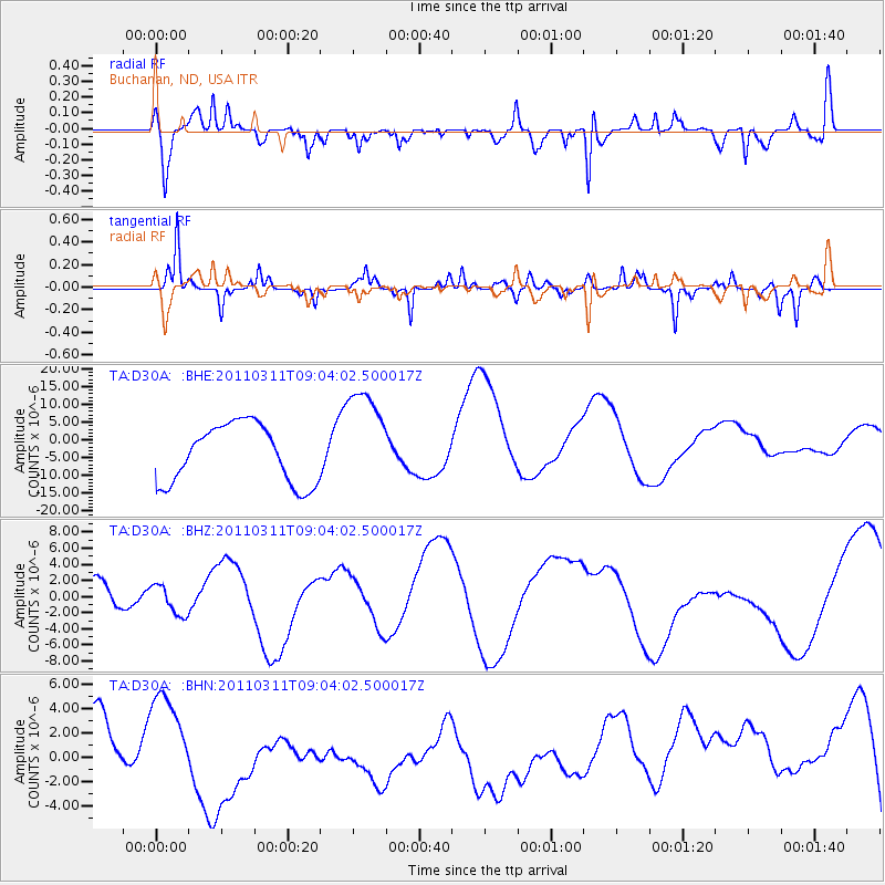
D30A Buchanan, ND, USA - Earthquake Result Viewer
*The percent match for this event was below the threshold and hence no stack was calculated.
| Earthquake location: |
Near East Coast Of Honshu, Japan |
| Earthquake latitude/longitude: |
36.8/141.9 |
| Earthquake time(UTC): |
2011/03/11 (070) 08:52:23 GMT |
| Earthquake Depth: |
17 km |
| Earthquake Magnitude: |
5.5 MB |
| Earthquake Catalog/Contributor: |
WHDF/NEIC |
|
| Network: |
TA USArray Transportable Network (new EarthScope stations) |
| Station: |
D30A Buchanan, ND, USA |
| Lat/Lon: |
47.11 N/98.76 W |
| Elevation: |
465 m |
|
| Distance: |
80.4 deg |
| Az: |
37.159 deg |
| Baz: |
314.76 deg |
| Ray Param: |
$rayparam |
*The percent match for this event was below the threshold and hence was not used in the summary stack. |
|
| Radial Match: |
42.126804 % |
| Radial Bump: |
362 |
| Transverse Match: |
53.8399 % |
| Transverse Bump: |
259 |
| SOD ConfigId: |
356183 |
| Insert Time: |
2011-08-14 02:27:58.650 +0000 |
| GWidth: |
2.5 |
| Max Bumps: |
400 |
| Tol: |
0.001 |
|
Signal To Noise
| Channel | StoN | STA | LTA |
| TA:D30A: :BHZ:20110311T09:04:02.500017Z | 0.34075946 | 1.8679925E-6 | 5.4818506E-6 |
| TA:D30A: :BHN:20110311T09:04:02.500017Z | 1.4300468 | 3.954651E-6 | 2.7653998E-6 |
| TA:D30A: :BHE:20110311T09:04:02.500017Z | 1.7872156 | 1.4663323E-5 | 8.204563E-6 |
| Arrivals |
| Ps | |
| PpPs | |
| PsPs/PpSs | |


