LVA2 AZ.LVA2 - Earthquake Result Viewer
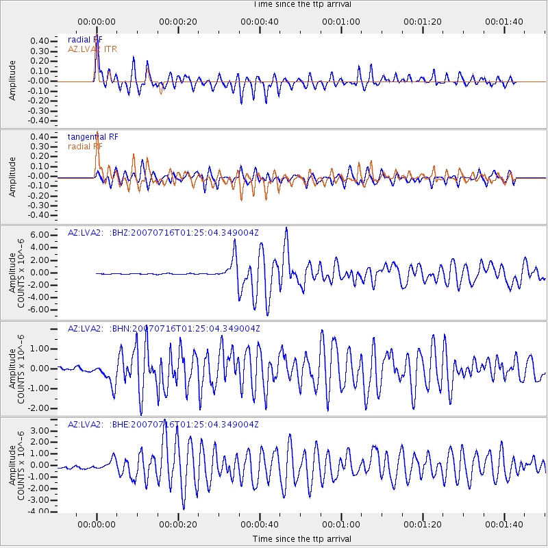
Earthquake location: Near West Coast Of Honshu, Japan
Earthquake latitude/longitude: 37.5/138.4
Earthquake time(UTC): 2007/07/16 (197) 01:13:22 GMT
Earthquake Depth: 12 km
Earthquake Magnitude: 6.5 MB, 6.4 MS, 6.6 MW, 6.5 MW
Earthquake Catalog/Contributor: WHDF/NEIC
Network: AZ ANZA Regional Network
Station: LVA2 AZ.LVA2
Lat/Lon: 33.35 N/116.56 W
Elevation: 1435 m
Distance: 80.8 deg
Az: 54.989 deg
Baz: 308.932 deg
Ray Param: 0.04802612
Estimated Moho Depth: 30.75 km
Estimated Crust Vp/Vs: 1.61
Assumed Crust Vp: 6.264 km/s
Estimated Crust Vs: 3.903 km/s
Estimated Crust Poisson's Ratio: 0.18
Radial Match: 90.68255 %
Radial Bump: 400
Transverse Match: 73.24589 %
Transverse Bump: 400
SOD ConfigId: 2564
Insert Time: 2010-02-26 19:50:44.227 +0000
GWidth: 2.5
Max Bumps: 400
Tol: 0.001

Signal To Noise

ChannelStoNSTALTA
AZ:LVA2: :BHN:20070716T01:25:04.349004Z5.66227966.3955423E-71.12949955E-7
AZ:LVA2: :BHE:20070716T01:25:04.349004Z3.60319644.5127015E-71.2524163E-7
AZ:LVA2: :BHZ:20070716T01:25:04.349004Z31.7985691.9849106E-66.242138E-8
Arrivals
Ps3.1 SECOND
PpPs12 SECOND
PsPs/PpSs15 SECOND