You are here: Home > Network List > TA - USArray Transportable Network (new EarthScope stations) Stations List
> Station K32A Verdigre, NE, USA > Earthquake Result Viewer
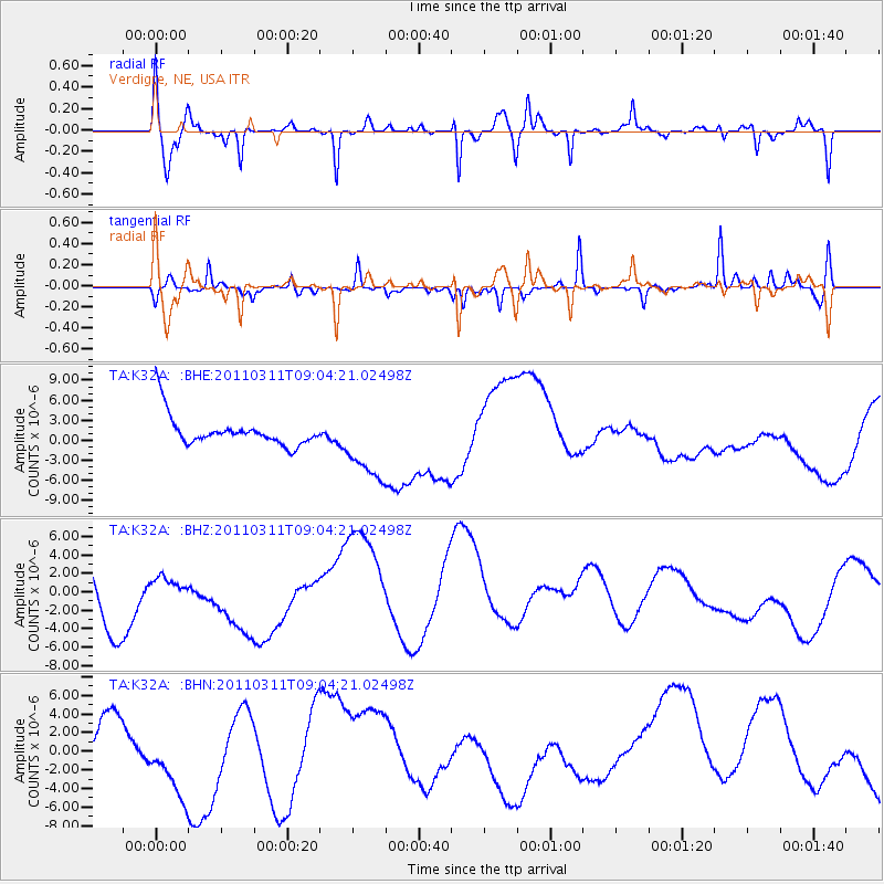
K32A Verdigre, NE, USA - Earthquake Result Viewer
*The percent match for this event was below the threshold and hence no stack was calculated.
| Earthquake location: |
Near East Coast Of Honshu, Japan |
| Earthquake latitude/longitude: |
36.8/141.9 |
| Earthquake time(UTC): |
2011/03/11 (070) 08:52:23 GMT |
| Earthquake Depth: |
17 km |
| Earthquake Magnitude: |
5.5 MB |
| Earthquake Catalog/Contributor: |
WHDF/NEIC |
|
| Network: |
TA USArray Transportable Network (new EarthScope stations) |
| Station: |
K32A Verdigre, NE, USA |
| Lat/Lon: |
42.66 N/97.97 W |
| Elevation: |
512 m |
|
| Distance: |
84.0 deg |
| Az: |
39.921 deg |
| Baz: |
315.689 deg |
| Ray Param: |
$rayparam |
*The percent match for this event was below the threshold and hence was not used in the summary stack. |
|
| Radial Match: |
73.852875 % |
| Radial Bump: |
372 |
| Transverse Match: |
40.25601 % |
| Transverse Bump: |
225 |
| SOD ConfigId: |
356183 |
| Insert Time: |
2011-08-14 02:45:07.324 +0000 |
| GWidth: |
2.5 |
| Max Bumps: |
400 |
| Tol: |
0.001 |
|
Signal To Noise
| Channel | StoN | STA | LTA |
| TA:K32A: :BHZ:20110311T09:04:21.02498Z | 0.18761002 | 5.780018E-7 | 3.0808685E-6 |
| TA:K32A: :BHN:20110311T09:04:21.02498Z | 1.2616025 | 4.2936495E-6 | 3.40333E-6 |
| TA:K32A: :BHE:20110311T09:04:21.02498Z | 2.4198725 | 5.4707107E-6 | 2.2607435E-6 |
| Arrivals |
| Ps | |
| PpPs | |
| PsPs/PpSs | |


