You are here: Home > Network List > TA - USArray Transportable Network (new EarthScope stations) Stations List
> Station J33A Davis, SD, USA > Earthquake Result Viewer
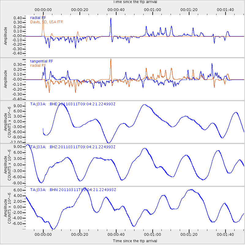
J33A Davis, SD, USA - Earthquake Result Viewer
*The percent match for this event was below the threshold and hence no stack was calculated.
| Earthquake location: |
Near East Coast Of Honshu, Japan |
| Earthquake latitude/longitude: |
36.8/141.9 |
| Earthquake time(UTC): |
2011/03/11 (070) 08:52:23 GMT |
| Earthquake Depth: |
17 km |
| Earthquake Magnitude: |
5.5 MB |
| Earthquake Catalog/Contributor: |
WHDF/NEIC |
|
| Network: |
TA USArray Transportable Network (new EarthScope stations) |
| Station: |
J33A Davis, SD, USA |
| Lat/Lon: |
43.32 N/96.97 W |
| Elevation: |
400 m |
|
| Distance: |
84.0 deg |
| Az: |
38.927 deg |
| Baz: |
316.268 deg |
| Ray Param: |
$rayparam |
*The percent match for this event was below the threshold and hence was not used in the summary stack. |
|
| Radial Match: |
47.399982 % |
| Radial Bump: |
244 |
| Transverse Match: |
21.670372 % |
| Transverse Bump: |
253 |
| SOD ConfigId: |
356183 |
| Insert Time: |
2011-08-14 02:46:19.039 +0000 |
| GWidth: |
2.5 |
| Max Bumps: |
400 |
| Tol: |
0.001 |
|
Signal To Noise
| Channel | StoN | STA | LTA |
| TA:J33A: :BHZ:20110311T09:04:21.224993Z | 1.581946 | 7.105428E-6 | 4.491574E-6 |
| TA:J33A: :BHN:20110311T09:04:21.224993Z | 3.1491704 | 7.678883E-6 | 2.4383828E-6 |
| TA:J33A: :BHE:20110311T09:04:21.224993Z | 1.0110936 | 5.82483E-6 | 5.760921E-6 |
| Arrivals |
| Ps | |
| PpPs | |
| PsPs/PpSs | |


