You are here: Home > Network List > TA - USArray Transportable Network (new EarthScope stations) Stations List
> Station A32A Rocking H Ranch, Lancaster, MN, USA > Earthquake Result Viewer
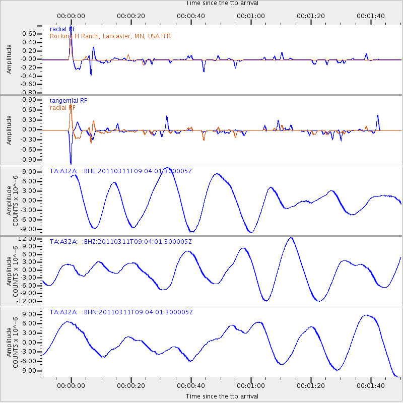
A32A Rocking H Ranch, Lancaster, MN, USA - Earthquake Result Viewer
*The percent match for this event was below the threshold and hence no stack was calculated.
| Earthquake location: |
Near East Coast Of Honshu, Japan |
| Earthquake latitude/longitude: |
36.8/141.9 |
| Earthquake time(UTC): |
2011/03/11 (070) 08:52:23 GMT |
| Earthquake Depth: |
17 km |
| Earthquake Magnitude: |
5.5 MB |
| Earthquake Catalog/Contributor: |
WHDF/NEIC |
|
| Network: |
TA USArray Transportable Network (new EarthScope stations) |
| Station: |
A32A Rocking H Ranch, Lancaster, MN, USA |
| Lat/Lon: |
48.92 N/96.49 W |
| Elevation: |
322 m |
|
| Distance: |
80.2 deg |
| Az: |
34.772 deg |
| Baz: |
316.036 deg |
| Ray Param: |
$rayparam |
*The percent match for this event was below the threshold and hence was not used in the summary stack. |
|
| Radial Match: |
65.231445 % |
| Radial Bump: |
255 |
| Transverse Match: |
44.237476 % |
| Transverse Bump: |
238 |
| SOD ConfigId: |
356183 |
| Insert Time: |
2011-08-14 02:55:21.409 +0000 |
| GWidth: |
2.5 |
| Max Bumps: |
400 |
| Tol: |
0.001 |
|
Signal To Noise
| Channel | StoN | STA | LTA |
| TA:A32A: :BHZ:20110311T09:04:01.300005Z | 0.6166121 | 1.949785E-6 | 3.1620934E-6 |
| TA:A32A: :BHN:20110311T09:04:01.300005Z | 2.8888435 | 6.078112E-6 | 2.1039948E-6 |
| TA:A32A: :BHE:20110311T09:04:01.300005Z | 1.9059094 | 1.0595028E-5 | 5.5590403E-6 |
| Arrivals |
| Ps | |
| PpPs | |
| PsPs/PpSs | |


