You are here: Home > Network List > CI - Caltech Regional Seismic Network Stations List
> Station ADO Adelanto Receiving Station, Victorville, CA, USA > Earthquake Result Viewer
ADO Adelanto Receiving Station, Victorville, CA, USA - Earthquake Result Viewer
| Earthquake location: |
Off East Coast Of Honshu, Japan |
| Earthquake latitude/longitude: |
37.7/143.3 |
| Earthquake time(UTC): |
2011/03/11 (070) 09:09:14 GMT |
| Earthquake Depth: |
39 km |
| Earthquake Magnitude: |
5.5 MB |
| Earthquake Catalog/Contributor: |
WHDF/NEIC |
|
| Network: |
CI Caltech Regional Seismic Network |
| Station: |
ADO Adelanto Receiving Station, Victorville, CA, USA |
| Lat/Lon: |
34.55 N/117.43 W |
| Elevation: |
908 m |
|
| Distance: |
76.2 deg |
| Az: |
57.016 deg |
| Baz: |
306.265 deg |
| Ray Param: |
0.051083464 |
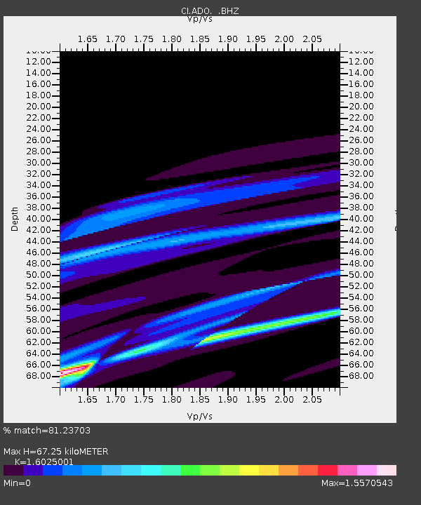
| Estimated Moho Depth: |
67.25 km |
| Estimated Crust Vp/Vs: |
1.60 |
| Assumed Crust Vp: |
6.276 km/s |
| Estimated Crust Vs: |
3.916 km/s |
| Estimated Crust Poisson's Ratio: |
0.18 |
|
| Radial Match: |
81.23703 % |
| Radial Bump: |
400 |
| Transverse Match: |
69.546 % |
| Transverse Bump: |
364 |
| SOD ConfigId: |
356183 |
| Insert Time: |
2011-08-14 03:30:29.442 +0000 |
| GWidth: |
2.5 |
| Max Bumps: |
400 |
| Tol: |
0.001 |
|

Signal To Noise
| Channel | StoN | STA | LTA |
| CI:ADO: :BHZ:20110311T09:20:27.969978Z | 0.5569243 | 2.262777E-6 | 4.0629884E-6 |
| CI:ADO: :BHN:20110311T09:20:27.969978Z | 3.9435513 | 9.397727E-6 | 2.3830619E-6 |
| CI:ADO: :BHE:20110311T09:20:27.969978Z | 0.45271057 | 1.8597832E-6 | 4.1081066E-6 |
| Arrivals |
| Ps | 6.7 SECOND |
| PpPs | 27 SECOND |
| PsPs/PpSs | 34 SECOND |


