You are here: Home > Network List > CN - Canadian National Seismograph Network Stations List
> Station INK INUVIK, NT, CANADA.ANADA > Earthquake Result Viewer
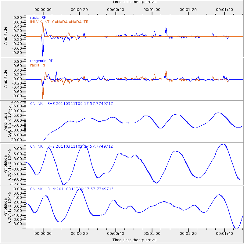
INK INUVIK, NT, CANADA.ANADA - Earthquake Result Viewer
*The percent match for this event was below the threshold and hence no stack was calculated.
| Earthquake location: |
Off East Coast Of Honshu, Japan |
| Earthquake latitude/longitude: |
37.7/143.3 |
| Earthquake time(UTC): |
2011/03/11 (070) 09:09:14 GMT |
| Earthquake Depth: |
39 km |
| Earthquake Magnitude: |
5.5 MB |
| Earthquake Catalog/Contributor: |
WHDF/NEIC |
|
| Network: |
CN Canadian National Seismograph Network |
| Station: |
INK INUVIK, NT, CANADA.ANADA |
| Lat/Lon: |
68.31 N/133.52 W |
| Elevation: |
40 m |
|
| Distance: |
53.1 deg |
| Az: |
27.484 deg |
| Baz: |
279.987 deg |
| Ray Param: |
$rayparam |
*The percent match for this event was below the threshold and hence was not used in the summary stack. |
|
| Radial Match: |
55.536575 % |
| Radial Bump: |
287 |
| Transverse Match: |
77.94796 % |
| Transverse Bump: |
400 |
| SOD ConfigId: |
356183 |
| Insert Time: |
2011-08-14 03:34:22.106 +0000 |
| GWidth: |
2.5 |
| Max Bumps: |
400 |
| Tol: |
0.001 |
|
Signal To Noise
| Channel | StoN | STA | LTA |
| CN:INK: :BHZ:20110311T09:17:57.774971Z | 0.9479309 | 5.76449E-6 | 6.0811294E-6 |
| CN:INK: :BHN:20110311T09:17:57.774971Z | 3.9258769 | 3.941581E-6 | 1.0040001E-6 |
| CN:INK: :BHE:20110311T09:17:57.774971Z | 0.7899329 | 5.245435E-6 | 6.6403554E-6 |
| Arrivals |
| Ps | |
| PpPs | |
| PsPs/PpSs | |


