You are here: Home > Network List > AZ - ANZA Regional Network Stations List
> Station LVA2 AZ.LVA2 > Earthquake Result Viewer
LVA2 AZ.LVA2 - Earthquake Result Viewer
| Earthquake location: |
Santa Cruz Islands |
| Earthquake latitude/longitude: |
-12.4/166.1 |
| Earthquake time(UTC): |
2009/10/07 (280) 22:50:15 GMT |
| Earthquake Depth: |
21 km |
| Earthquake Magnitude: |
5.8 MB |
| Earthquake Catalog/Contributor: |
WHDF/NEIC |
|
| Network: |
AZ ANZA Regional Network |
| Station: |
LVA2 AZ.LVA2 |
| Lat/Lon: |
33.35 N/116.56 W |
| Elevation: |
1435 m |
|
| Distance: |
86.4 deg |
| Az: |
54.914 deg |
| Baz: |
252.778 deg |
| Ray Param: |
0.044043846 |
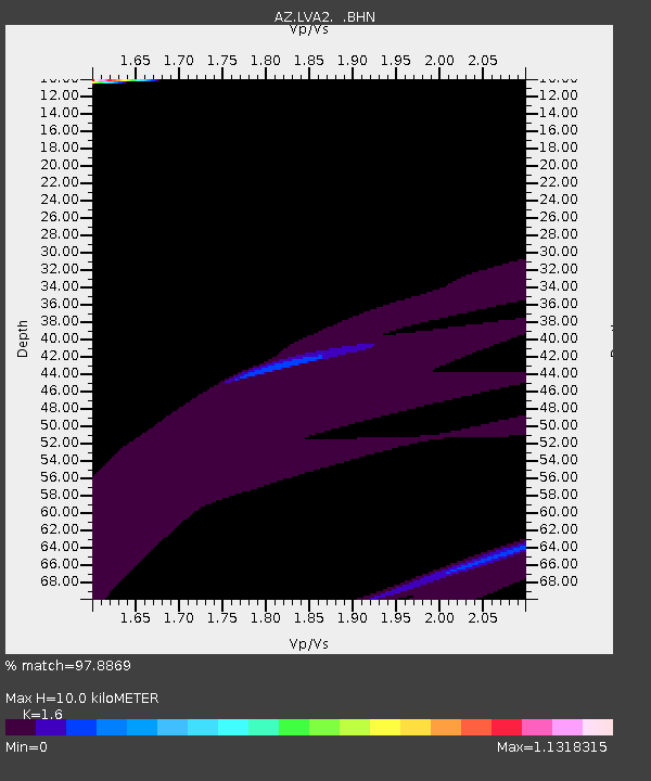
| Estimated Moho Depth: |
10.0 km |
| Estimated Crust Vp/Vs: |
1.60 |
| Assumed Crust Vp: |
6.264 km/s |
| Estimated Crust Vs: |
3.915 km/s |
| Estimated Crust Poisson's Ratio: |
0.18 |
|
| Radial Match: |
97.8869 % |
| Radial Bump: |
307 |
| Transverse Match: |
93.38398 % |
| Transverse Bump: |
198 |
| SOD ConfigId: |
2622 |
| Insert Time: |
2010-02-26 19:51:03.470 +0000 |
| GWidth: |
2.5 |
| Max Bumps: |
400 |
| Tol: |
0.001 |
|
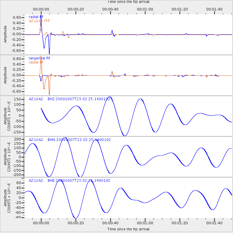
Signal To Noise
| Channel | StoN | STA | LTA |
| AZ:LVA2: :BHN:20091007T23:02:25.149019Z | 1.7171619 | 1.5388832E-4 | 8.9617824E-5 |
| AZ:LVA2: :BHE:20091007T23:02:25.149019Z | 2.9900312 | 5.527804E-5 | 1.8487446E-5 |
| AZ:LVA2: :BHZ:20091007T23:02:25.149019Z | 2.333302 | 1.2491246E-4 | 5.353463E-5 |
| Arrivals |
| Ps | 1.0 SECOND |
| PpPs | 4.1 SECOND |
| PsPs/PpSs | 5.0 SECOND |


