You are here: Home > Network List > NE - New England Seismic Network Stations List
> Station BRYW Smithfield, RI > Earthquake Result Viewer
BRYW Smithfield, RI - Earthquake Result Viewer
| Earthquake location: |
Off East Coast Of Honshu, Japan |
| Earthquake latitude/longitude: |
37.7/143.3 |
| Earthquake time(UTC): |
2011/03/11 (070) 09:09:14 GMT |
| Earthquake Depth: |
39 km |
| Earthquake Magnitude: |
5.5 MB |
| Earthquake Catalog/Contributor: |
WHDF/NEIC |
|
| Network: |
NE New England Seismic Network |
| Station: |
BRYW Smithfield, RI |
| Lat/Lon: |
41.92 N/71.54 W |
| Elevation: |
107 m |
|
| Distance: |
94.6 deg |
| Az: |
25.332 deg |
| Baz: |
332.945 deg |
| Ray Param: |
0.04097631 |
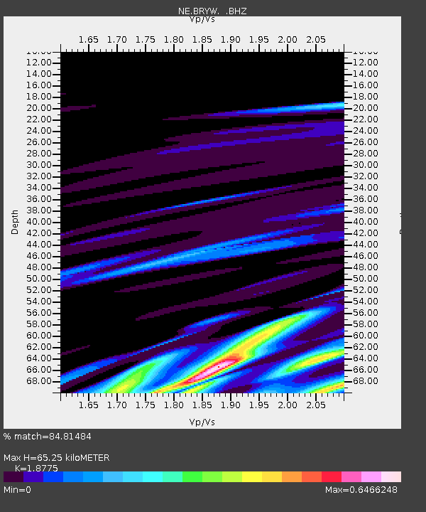
| Estimated Moho Depth: |
65.25 km |
| Estimated Crust Vp/Vs: |
1.88 |
| Assumed Crust Vp: |
6.472 km/s |
| Estimated Crust Vs: |
3.447 km/s |
| Estimated Crust Poisson's Ratio: |
0.30 |
|
| Radial Match: |
84.81484 % |
| Radial Bump: |
400 |
| Transverse Match: |
60.97421 % |
| Transverse Bump: |
324 |
| SOD ConfigId: |
356183 |
| Insert Time: |
2011-08-14 03:48:18.111 +0000 |
| GWidth: |
2.5 |
| Max Bumps: |
400 |
| Tol: |
0.001 |
|

Signal To Noise
| Channel | StoN | STA | LTA |
| NE:BRYW: :BHZ:20110311T09:22:00.140022Z | 2.2821677 | 6.6177304E-6 | 2.8997565E-6 |
| NE:BRYW: :BHN:20110311T09:22:00.140022Z | 2.2451706 | 6.343912E-6 | 2.825581E-6 |
| NE:BRYW: :BHE:20110311T09:22:00.140022Z | 1.4760177 | 8.330726E-6 | 5.644056E-6 |
| Arrivals |
| Ps | 9.0 SECOND |
| PpPs | 28 SECOND |
| PsPs/PpSs | 37 SECOND |


