You are here: Home > Network List > TA - USArray Transportable Network (new EarthScope stations) Stations List
> Station P31A Stockton, KS, USA > Earthquake Result Viewer
P31A Stockton, KS, USA - Earthquake Result Viewer
*The percent match for this event was below the threshold and hence no stack was calculated.
| Earthquake location: |
Off East Coast Of Honshu, Japan |
| Earthquake latitude/longitude: |
37.7/143.3 |
| Earthquake time(UTC): |
2011/03/11 (070) 09:09:14 GMT |
| Earthquake Depth: |
39 km |
| Earthquake Magnitude: |
5.5 MB |
| Earthquake Catalog/Contributor: |
WHDF/NEIC |
|
| Network: |
TA USArray Transportable Network (new EarthScope stations) |
| Station: |
P31A Stockton, KS, USA |
| Lat/Lon: |
39.52 N/99.38 W |
| Elevation: |
665 m |
|
| Distance: |
84.0 deg |
| Az: |
43.712 deg |
| Baz: |
314.862 deg |
| Ray Param: |
$rayparam |
*The percent match for this event was below the threshold and hence was not used in the summary stack. |
|
| Radial Match: |
79.469284 % |
| Radial Bump: |
200 |
| Transverse Match: |
70.60065 % |
| Transverse Bump: |
352 |
| SOD ConfigId: |
356183 |
| Insert Time: |
2011-08-14 03:57:28.817 +0000 |
| GWidth: |
2.5 |
| Max Bumps: |
400 |
| Tol: |
0.001 |
|
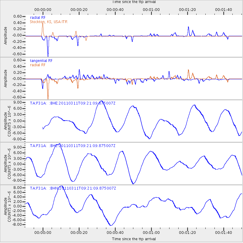
Signal To Noise
| Channel | StoN | STA | LTA |
| TA:P31A: :BHZ:20110311T09:21:09.875007Z | 0.9114624 | 4.248705E-6 | 4.6614155E-6 |
| TA:P31A: :BHN:20110311T09:21:09.875007Z | 1.137326 | 2.884629E-6 | 2.5363258E-6 |
| TA:P31A: :BHE:20110311T09:21:09.875007Z | 3.7749143 | 9.448312E-6 | 2.5029208E-6 |
| Arrivals |
| Ps | |
| PpPs | |
| PsPs/PpSs | |


