You are here: Home > Network List > TA - USArray Transportable Network (new EarthScope stations) Stations List
> Station R37A Teagarden Farms, La Cygne, KS, USA > Earthquake Result Viewer
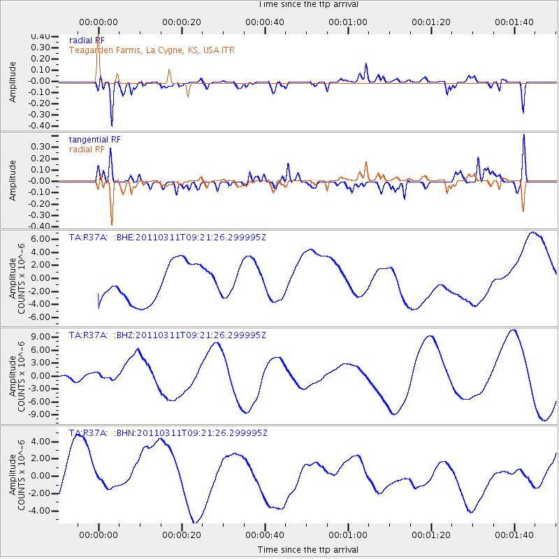
R37A Teagarden Farms, La Cygne, KS, USA - Earthquake Result Viewer
*The percent match for this event was below the threshold and hence no stack was calculated.
| Earthquake location: |
Off East Coast Of Honshu, Japan |
| Earthquake latitude/longitude: |
37.7/143.3 |
| Earthquake time(UTC): |
2011/03/11 (070) 09:09:14 GMT |
| Earthquake Depth: |
39 km |
| Earthquake Magnitude: |
5.5 MB |
| Earthquake Catalog/Contributor: |
WHDF/NEIC |
|
| Network: |
TA USArray Transportable Network (new EarthScope stations) |
| Station: |
R37A Teagarden Farms, La Cygne, KS, USA |
| Lat/Lon: |
38.31 N/94.83 W |
| Elevation: |
298 m |
|
| Distance: |
87.3 deg |
| Az: |
41.979 deg |
| Baz: |
317.578 deg |
| Ray Param: |
$rayparam |
*The percent match for this event was below the threshold and hence was not used in the summary stack. |
|
| Radial Match: |
61.812943 % |
| Radial Bump: |
388 |
| Transverse Match: |
54.52653 % |
| Transverse Bump: |
371 |
| SOD ConfigId: |
356183 |
| Insert Time: |
2011-08-14 04:13:31.479 +0000 |
| GWidth: |
2.5 |
| Max Bumps: |
400 |
| Tol: |
0.001 |
|
Signal To Noise
| Channel | StoN | STA | LTA |
| TA:R37A: :BHZ:20110311T09:21:26.299995Z | 0.29713786 | 1.1115153E-6 | 3.7407394E-6 |
| TA:R37A: :BHN:20110311T09:21:26.299995Z | 0.36727688 | 1.0240194E-6 | 2.7881401E-6 |
| TA:R37A: :BHE:20110311T09:21:26.299995Z | 0.67136425 | 1.943679E-6 | 2.8951185E-6 |
| Arrivals |
| Ps | |
| PpPs | |
| PsPs/PpSs | |


