You are here: Home > Network List > TA - USArray Transportable Network (new EarthScope stations) Stations List
> Station K37A Belmond, IA, USA > Earthquake Result Viewer
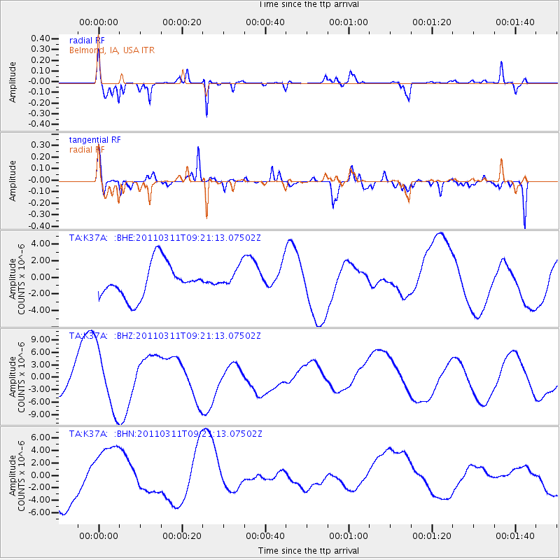
K37A Belmond, IA, USA - Earthquake Result Viewer
*The percent match for this event was below the threshold and hence no stack was calculated.
| Earthquake location: |
Off East Coast Of Honshu, Japan |
| Earthquake latitude/longitude: |
37.7/143.3 |
| Earthquake time(UTC): |
2011/03/11 (070) 09:09:14 GMT |
| Earthquake Depth: |
39 km |
| Earthquake Magnitude: |
5.5 MB |
| Earthquake Catalog/Contributor: |
WHDF/NEIC |
|
| Network: |
TA USArray Transportable Network (new EarthScope stations) |
| Station: |
K37A Belmond, IA, USA |
| Lat/Lon: |
42.77 N/93.64 W |
| Elevation: |
365 m |
|
| Distance: |
84.7 deg |
| Az: |
38.311 deg |
| Baz: |
318.093 deg |
| Ray Param: |
$rayparam |
*The percent match for this event was below the threshold and hence was not used in the summary stack. |
|
| Radial Match: |
55.916233 % |
| Radial Bump: |
263 |
| Transverse Match: |
53.585167 % |
| Transverse Bump: |
400 |
| SOD ConfigId: |
356183 |
| Insert Time: |
2011-08-14 04:27:19.734 +0000 |
| GWidth: |
2.5 |
| Max Bumps: |
400 |
| Tol: |
0.001 |
|
Signal To Noise
| Channel | StoN | STA | LTA |
| TA:K37A: :BHZ:20110311T09:21:13.07502Z | 3.169506 | 7.2110915E-6 | 2.2751467E-6 |
| TA:K37A: :BHN:20110311T09:21:13.07502Z | 1.3073357 | 5.4369148E-6 | 4.1587746E-6 |
| TA:K37A: :BHE:20110311T09:21:13.07502Z | 0.68853074 | 1.4123603E-6 | 2.0512668E-6 |
| Arrivals |
| Ps | |
| PpPs | |
| PsPs/PpSs | |


