You are here: Home > Network List > TA - USArray Transportable Network (new EarthScope stations) Stations List
> Station S39A Bolivar, MO, USA > Earthquake Result Viewer
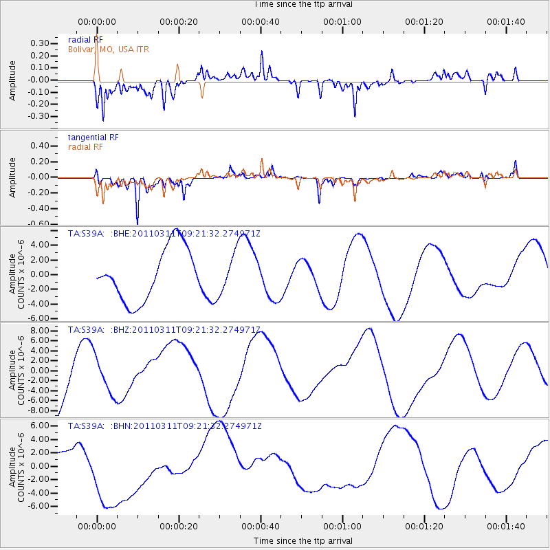
S39A Bolivar, MO, USA - Earthquake Result Viewer
*The percent match for this event was below the threshold and hence no stack was calculated.
| Earthquake location: |
Off East Coast Of Honshu, Japan |
| Earthquake latitude/longitude: |
37.7/143.3 |
| Earthquake time(UTC): |
2011/03/11 (070) 09:09:14 GMT |
| Earthquake Depth: |
39 km |
| Earthquake Magnitude: |
5.5 MB |
| Earthquake Catalog/Contributor: |
WHDF/NEIC |
|
| Network: |
TA USArray Transportable Network (new EarthScope stations) |
| Station: |
S39A Bolivar, MO, USA |
| Lat/Lon: |
37.69 N/93.32 W |
| Elevation: |
331 m |
|
| Distance: |
88.6 deg |
| Az: |
41.509 deg |
| Baz: |
318.485 deg |
| Ray Param: |
$rayparam |
*The percent match for this event was below the threshold and hence was not used in the summary stack. |
|
| Radial Match: |
75.83415 % |
| Radial Bump: |
343 |
| Transverse Match: |
79.48675 % |
| Transverse Bump: |
272 |
| SOD ConfigId: |
356183 |
| Insert Time: |
2011-08-14 04:32:38.304 +0000 |
| GWidth: |
2.5 |
| Max Bumps: |
400 |
| Tol: |
0.001 |
|
Signal To Noise
| Channel | StoN | STA | LTA |
| TA:S39A: :BHZ:20110311T09:21:32.274971Z | 0.7174876 | 3.7060247E-6 | 5.1652805E-6 |
| TA:S39A: :BHN:20110311T09:21:32.274971Z | 2.509337 | 6.520807E-6 | 2.5986176E-6 |
| TA:S39A: :BHE:20110311T09:21:32.274971Z | 0.8052506 | 2.8743389E-6 | 3.5694961E-6 |
| Arrivals |
| Ps | |
| PpPs | |
| PsPs/PpSs | |


