You are here: Home > Network List > TA - USArray Transportable Network (new EarthScope stations) Stations List
> Station O03E Paynes Creek, CA, USA > Earthquake Result Viewer
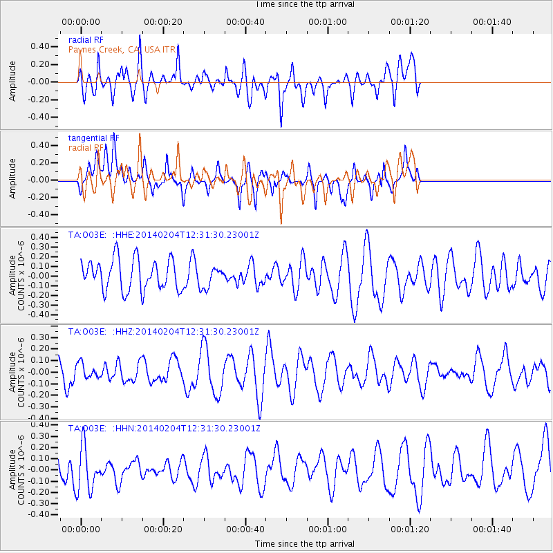
O03E Paynes Creek, CA, USA - Earthquake Result Viewer
*The percent match for this event was below the threshold and hence no stack was calculated.
| Earthquake location: |
Philippine Islands Region |
| Earthquake latitude/longitude: |
19.3/121.1 |
| Earthquake time(UTC): |
2014/02/04 (035) 12:18:34 GMT |
| Earthquake Depth: |
37 km |
| Earthquake Magnitude: |
5.0 MW |
| Earthquake Catalog/Contributor: |
ISC/ISC |
|
| Network: |
TA USArray Transportable Network (new EarthScope stations) |
| Station: |
O03E Paynes Creek, CA, USA |
| Lat/Lon: |
40.29 N/121.80 W |
| Elevation: |
967 m |
|
| Distance: |
96.7 deg |
| Az: |
43.282 deg |
| Baz: |
302.161 deg |
| Ray Param: |
$rayparam |
*The percent match for this event was below the threshold and hence was not used in the summary stack. |
|
| Radial Match: |
58.01482 % |
| Radial Bump: |
400 |
| Transverse Match: |
50.322357 % |
| Transverse Bump: |
400 |
| SOD ConfigId: |
3390531 |
| Insert Time: |
2019-04-10 05:40:15.728 +0000 |
| GWidth: |
2.5 |
| Max Bumps: |
400 |
| Tol: |
0.001 |
|
Signal To Noise
| Channel | StoN | STA | LTA |
| TA:O03E: :HHZ:20140204T12:31:30.23001Z | 0.48723495 | 6.428573E-8 | 1.319399E-7 |
| TA:O03E: :HHN:20140204T12:31:30.23001Z | 1.653141 | 2.0273343E-7 | 1.2263529E-7 |
| TA:O03E: :HHE:20140204T12:31:30.23001Z | 0.6818812 | 1.0874676E-7 | 1.594805E-7 |
| Arrivals |
| Ps | |
| PpPs | |
| PsPs/PpSs | |


