You are here: Home > Network List > TA - USArray Transportable Network (new EarthScope stations) Stations List
> Station H28A Mission Ridge, SD, USA > Earthquake Result Viewer
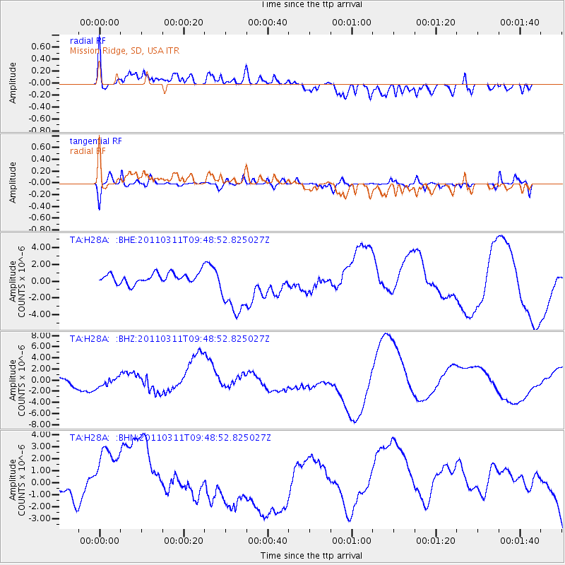
H28A Mission Ridge, SD, USA - Earthquake Result Viewer
*The percent match for this event was below the threshold and hence no stack was calculated.
| Earthquake location: |
Near East Coast Of Honshu, Japan |
| Earthquake latitude/longitude: |
35.9/141.6 |
| Earthquake time(UTC): |
2011/03/11 (070) 09:37:04 GMT |
| Earthquake Depth: |
5.8 km |
| Earthquake Magnitude: |
5.5 MB |
| Earthquake Catalog/Contributor: |
WHDF/NEIC |
|
| Network: |
TA USArray Transportable Network (new EarthScope stations) |
| Station: |
H28A Mission Ridge, SD, USA |
| Lat/Lon: |
44.68 N/101.02 W |
| Elevation: |
642 m |
|
| Distance: |
81.8 deg |
| Az: |
39.8 deg |
| Baz: |
313.254 deg |
| Ray Param: |
$rayparam |
*The percent match for this event was below the threshold and hence was not used in the summary stack. |
|
| Radial Match: |
42.876396 % |
| Radial Bump: |
400 |
| Transverse Match: |
48.020706 % |
| Transverse Bump: |
400 |
| SOD ConfigId: |
356183 |
| Insert Time: |
2011-08-14 05:44:41.674 +0000 |
| GWidth: |
2.5 |
| Max Bumps: |
400 |
| Tol: |
0.001 |
|
Signal To Noise
| Channel | StoN | STA | LTA |
| TA:H28A: :BHZ:20110311T09:48:52.825027Z | 0.27361396 | 8.30163E-7 | 3.0340666E-6 |
| TA:H28A: :BHN:20110311T09:48:52.825027Z | 2.8731701 | 3.9211022E-6 | 1.3647302E-6 |
| TA:H28A: :BHE:20110311T09:48:52.825027Z | 5.7186375 | 3.4724876E-6 | 6.072229E-7 |
| Arrivals |
| Ps | |
| PpPs | |
| PsPs/PpSs | |


