You are here: Home > Network List > TA - USArray Transportable Network (new EarthScope stations) Stations List
> Station C30A Mose, Pekin, ND, USA > Earthquake Result Viewer
C30A Mose, Pekin, ND, USA - Earthquake Result Viewer
| Earthquake location: |
Near East Coast Of Honshu, Japan |
| Earthquake latitude/longitude: |
35.9/141.6 |
| Earthquake time(UTC): |
2011/03/11 (070) 09:37:04 GMT |
| Earthquake Depth: |
5.8 km |
| Earthquake Magnitude: |
5.5 MB |
| Earthquake Catalog/Contributor: |
WHDF/NEIC |
|
| Network: |
TA USArray Transportable Network (new EarthScope stations) |
| Station: |
C30A Mose, Pekin, ND, USA |
| Lat/Lon: |
47.70 N/98.48 W |
| Elevation: |
480 m |
|
| Distance: |
81.0 deg |
| Az: |
36.355 deg |
| Baz: |
314.567 deg |
| Ray Param: |
0.047929574 |
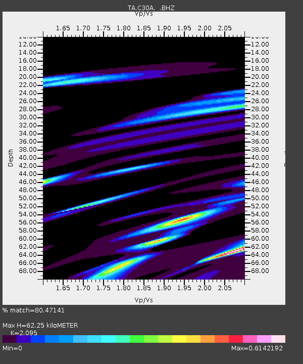
| Estimated Moho Depth: |
62.25 km |
| Estimated Crust Vp/Vs: |
2.10 |
| Assumed Crust Vp: |
6.53 km/s |
| Estimated Crust Vs: |
3.117 km/s |
| Estimated Crust Poisson's Ratio: |
0.35 |
|
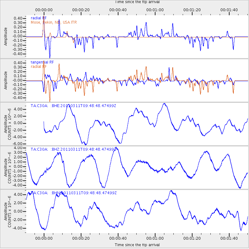
| Radial Match: |
80.47141 % |
| Radial Bump: |
381 |
| Transverse Match: |
48.923683 % |
| Transverse Bump: |
400 |
| SOD ConfigId: |
356183 |
| Insert Time: |
2011-08-14 05:47:44.693 +0000 |
| GWidth: |
2.5 |
| Max Bumps: |
400 |
| Tol: |
0.001 |
|
Signal To Noise
| Channel | StoN | STA | LTA |
| TA:C30A: :BHZ:20110311T09:48:48.47499Z | 0.6988125 | 2.284645E-6 | 3.269325E-6 |
| TA:C30A: :BHN:20110311T09:48:48.47499Z | 0.91793567 | 2.8948443E-6 | 3.153646E-6 |
| TA:C30A: :BHE:20110311T09:48:48.47499Z | 0.32278305 | 1.018212E-6 | 3.1544778E-6 |
| Arrivals |
| Ps | 11 SECOND |
| PpPs | 29 SECOND |
| PsPs/PpSs | 39 SECOND |


