You are here: Home > Network List > TA - USArray Transportable Network (new EarthScope stations) Stations List
> Station L02D Cave Junction, OR, USA > Earthquake Result Viewer
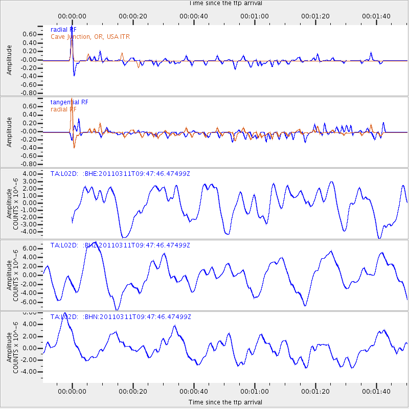
L02D Cave Junction, OR, USA - Earthquake Result Viewer
*The percent match for this event was below the threshold and hence no stack was calculated.
| Earthquake location: |
Near East Coast Of Honshu, Japan |
| Earthquake latitude/longitude: |
35.9/141.6 |
| Earthquake time(UTC): |
2011/03/11 (070) 09:37:04 GMT |
| Earthquake Depth: |
5.8 km |
| Earthquake Magnitude: |
5.5 MB |
| Earthquake Catalog/Contributor: |
WHDF/NEIC |
|
| Network: |
TA USArray Transportable Network (new EarthScope stations) |
| Station: |
L02D Cave Junction, OR, USA |
| Lat/Lon: |
42.16 N/123.60 W |
| Elevation: |
458 m |
|
| Distance: |
70.1 deg |
| Az: |
51.988 deg |
| Baz: |
300.661 deg |
| Ray Param: |
$rayparam |
*The percent match for this event was below the threshold and hence was not used in the summary stack. |
|
| Radial Match: |
57.60063 % |
| Radial Bump: |
400 |
| Transverse Match: |
54.432667 % |
| Transverse Bump: |
400 |
| SOD ConfigId: |
356183 |
| Insert Time: |
2011-08-14 05:55:13.686 +0000 |
| GWidth: |
2.5 |
| Max Bumps: |
400 |
| Tol: |
0.001 |
|
Signal To Noise
| Channel | StoN | STA | LTA |
| TA:L02D: :BHZ:20110311T09:47:46.47499Z | 1.5595002 | 3.135183E-6 | 2.0103769E-6 |
| TA:L02D: :BHN:20110311T09:47:46.47499Z | 1.3672878 | 4.054843E-6 | 2.9656103E-6 |
| TA:L02D: :BHE:20110311T09:47:46.47499Z | 0.968416 | 2.062382E-6 | 2.1296448E-6 |
| Arrivals |
| Ps | |
| PpPs | |
| PsPs/PpSs | |


