You are here: Home > Network List > TA - USArray Transportable Network (new EarthScope stations) Stations List
> Station 339A Huntington, TX, USA > Earthquake Result Viewer
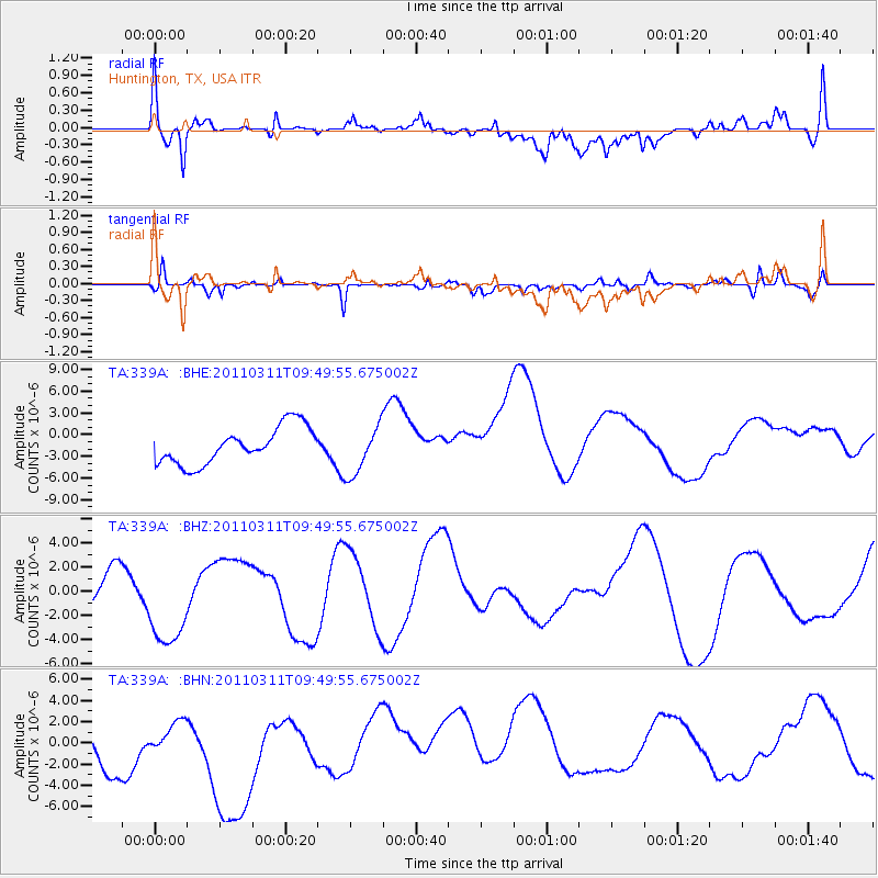
339A Huntington, TX, USA - Earthquake Result Viewer
*The percent match for this event was below the threshold and hence no stack was calculated.
| Earthquake location: |
Near East Coast Of Honshu, Japan |
| Earthquake latitude/longitude: |
35.9/141.6 |
| Earthquake time(UTC): |
2011/03/11 (070) 09:37:04 GMT |
| Earthquake Depth: |
5.8 km |
| Earthquake Magnitude: |
5.5 MB |
| Earthquake Catalog/Contributor: |
WHDF/NEIC |
|
| Network: |
TA USArray Transportable Network (new EarthScope stations) |
| Station: |
339A Huntington, TX, USA |
| Lat/Lon: |
31.33 N/94.56 W |
| Elevation: |
82 m |
|
| Distance: |
94.9 deg |
| Az: |
45.503 deg |
| Baz: |
317.416 deg |
| Ray Param: |
$rayparam |
*The percent match for this event was below the threshold and hence was not used in the summary stack. |
|
| Radial Match: |
60.87769 % |
| Radial Bump: |
400 |
| Transverse Match: |
57.70273 % |
| Transverse Bump: |
400 |
| SOD ConfigId: |
356183 |
| Insert Time: |
2011-08-14 05:57:52.059 +0000 |
| GWidth: |
2.5 |
| Max Bumps: |
400 |
| Tol: |
0.001 |
|
Signal To Noise
| Channel | StoN | STA | LTA |
| TA:339A: :BHZ:20110311T09:49:55.675002Z | 2.6417205 | 3.9259835E-6 | 1.4861464E-6 |
| TA:339A: :BHN:20110311T09:49:55.675002Z | 0.56245744 | 1.8008924E-6 | 3.2018286E-6 |
| TA:339A: :BHE:20110311T09:49:55.675002Z | 1.3451853 | 3.4102868E-6 | 2.53518E-6 |
| Arrivals |
| Ps | |
| PpPs | |
| PsPs/PpSs | |


