You are here: Home > Network List > TA - USArray Transportable Network (new EarthScope stations) Stations List
> Station N35A Tabor, IA, USA > Earthquake Result Viewer
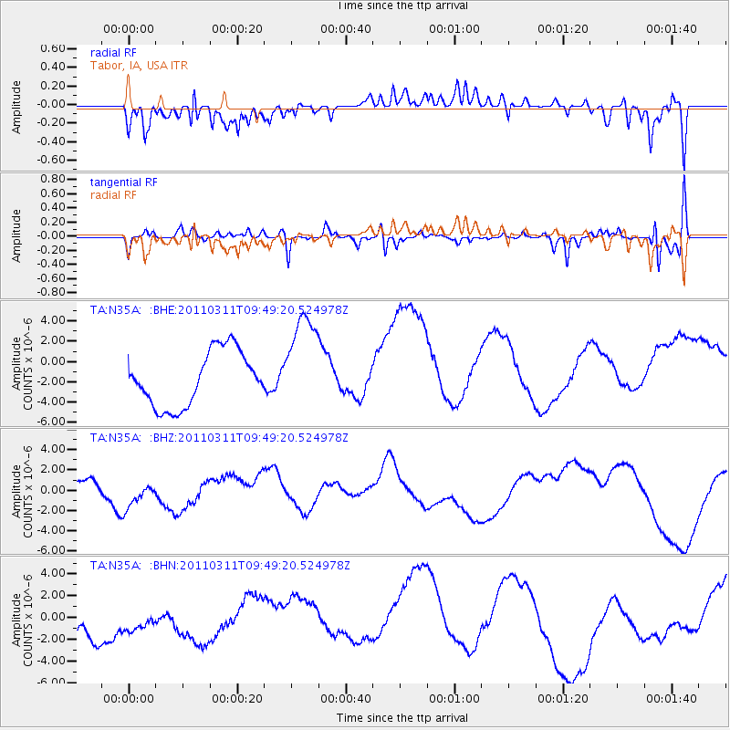
N35A Tabor, IA, USA - Earthquake Result Viewer
*The percent match for this event was below the threshold and hence no stack was calculated.
| Earthquake location: |
Near East Coast Of Honshu, Japan |
| Earthquake latitude/longitude: |
35.9/141.6 |
| Earthquake time(UTC): |
2011/03/11 (070) 09:37:04 GMT |
| Earthquake Depth: |
5.8 km |
| Earthquake Magnitude: |
5.5 MB |
| Earthquake Catalog/Contributor: |
WHDF/NEIC |
|
| Network: |
TA USArray Transportable Network (new EarthScope stations) |
| Station: |
N35A Tabor, IA, USA |
| Lat/Lon: |
40.86 N/95.64 W |
| Elevation: |
353 m |
|
| Distance: |
87.3 deg |
| Az: |
39.685 deg |
| Baz: |
316.885 deg |
| Ray Param: |
$rayparam |
*The percent match for this event was below the threshold and hence was not used in the summary stack. |
|
| Radial Match: |
52.51774 % |
| Radial Bump: |
324 |
| Transverse Match: |
46.155907 % |
| Transverse Bump: |
378 |
| SOD ConfigId: |
356183 |
| Insert Time: |
2011-08-14 06:01:50.622 +0000 |
| GWidth: |
2.5 |
| Max Bumps: |
400 |
| Tol: |
0.001 |
|
Signal To Noise
| Channel | StoN | STA | LTA |
| TA:N35A: :BHZ:20110311T09:49:20.524978Z | 1.0296358 | 1.5476778E-6 | 1.5031313E-6 |
| TA:N35A: :BHN:20110311T09:49:20.524978Z | 1.0546485 | 2.0239318E-6 | 1.9190581E-6 |
| TA:N35A: :BHE:20110311T09:49:20.524978Z | 1.8648905 | 5.0006315E-6 | 2.6814612E-6 |
| Arrivals |
| Ps | |
| PpPs | |
| PsPs/PpSs | |


