You are here: Home > Network List > TA - USArray Transportable Network (new EarthScope stations) Stations List
> Station O03D Paynes Creek, CA, USA > Earthquake Result Viewer
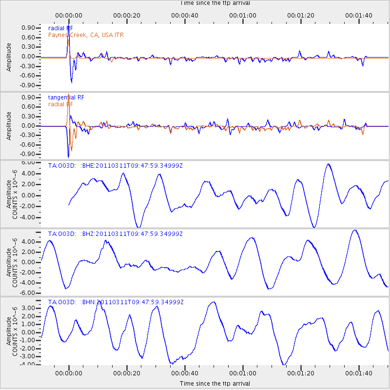
O03D Paynes Creek, CA, USA - Earthquake Result Viewer
*The percent match for this event was below the threshold and hence no stack was calculated.
| Earthquake location: |
Near East Coast Of Honshu, Japan |
| Earthquake latitude/longitude: |
35.9/141.6 |
| Earthquake time(UTC): |
2011/03/11 (070) 09:37:04 GMT |
| Earthquake Depth: |
5.8 km |
| Earthquake Magnitude: |
5.5 MB |
| Earthquake Catalog/Contributor: |
WHDF/NEIC |
|
| Network: |
TA USArray Transportable Network (new EarthScope stations) |
| Station: |
O03D Paynes Creek, CA, USA |
| Lat/Lon: |
40.29 N/121.80 W |
| Elevation: |
968 m |
|
| Distance: |
72.3 deg |
| Az: |
52.918 deg |
| Baz: |
302.144 deg |
| Ray Param: |
$rayparam |
*The percent match for this event was below the threshold and hence was not used in the summary stack. |
|
| Radial Match: |
48.43216 % |
| Radial Bump: |
388 |
| Transverse Match: |
59.37763 % |
| Transverse Bump: |
400 |
| SOD ConfigId: |
356183 |
| Insert Time: |
2011-08-14 06:05:08.717 +0000 |
| GWidth: |
2.5 |
| Max Bumps: |
400 |
| Tol: |
0.001 |
|
Signal To Noise
| Channel | StoN | STA | LTA |
| TA:O03D: :BHZ:20110311T09:47:59.34999Z | 1.6564465 | 3.0001058E-6 | 1.8111698E-6 |
| TA:O03D: :BHN:20110311T09:47:59.34999Z | 0.7845359 | 1.5464622E-6 | 1.971181E-6 |
| TA:O03D: :BHE:20110311T09:47:59.34999Z | 0.8066054 | 1.9635527E-6 | 2.434341E-6 |
| Arrivals |
| Ps | |
| PpPs | |
| PsPs/PpSs | |


