You are here: Home > Network List > TA - USArray Transportable Network (new EarthScope stations) Stations List
> Station J01D Myrtle Point, OR, USA > Earthquake Result Viewer
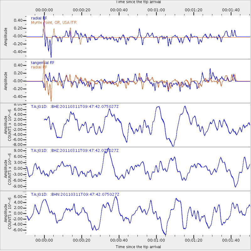
J01D Myrtle Point, OR, USA - Earthquake Result Viewer
*The percent match for this event was below the threshold and hence no stack was calculated.
| Earthquake location: |
Near East Coast Of Honshu, Japan |
| Earthquake latitude/longitude: |
35.9/141.6 |
| Earthquake time(UTC): |
2011/03/11 (070) 09:37:04 GMT |
| Earthquake Depth: |
5.8 km |
| Earthquake Magnitude: |
5.5 MB |
| Earthquake Catalog/Contributor: |
WHDF/NEIC |
|
| Network: |
TA USArray Transportable Network (new EarthScope stations) |
| Station: |
J01D Myrtle Point, OR, USA |
| Lat/Lon: |
43.16 N/123.93 W |
| Elevation: |
131 m |
|
| Distance: |
69.4 deg |
| Az: |
51.196 deg |
| Baz: |
300.166 deg |
| Ray Param: |
$rayparam |
*The percent match for this event was below the threshold and hence was not used in the summary stack. |
|
| Radial Match: |
62.22232 % |
| Radial Bump: |
400 |
| Transverse Match: |
62.273144 % |
| Transverse Bump: |
393 |
| SOD ConfigId: |
356183 |
| Insert Time: |
2011-08-14 06:05:56.039 +0000 |
| GWidth: |
2.5 |
| Max Bumps: |
400 |
| Tol: |
0.001 |
|
Signal To Noise
| Channel | StoN | STA | LTA |
| TA:J01D: :BHZ:20110311T09:47:42.075027Z | 0.81270915 | 3.1567963E-6 | 3.8842877E-6 |
| TA:J01D: :BHN:20110311T09:47:42.075027Z | 1.3407526 | 5.6076447E-6 | 4.1824605E-6 |
| TA:J01D: :BHE:20110311T09:47:42.075027Z | 1.1276983 | 3.0938736E-6 | 2.7435294E-6 |
| Arrivals |
| Ps | |
| PpPs | |
| PsPs/PpSs | |


