You are here: Home > Network List > UW - Pacific Northwest Regional Seismic Network Stations List
> Station MRBL Marblemount, WA, USA > Earthquake Result Viewer
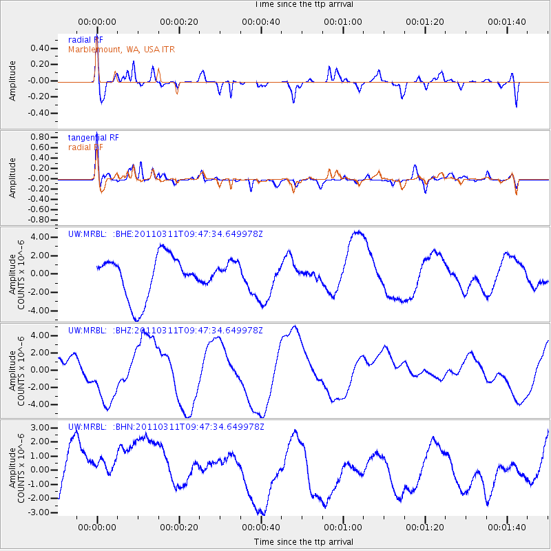
MRBL Marblemount, WA, USA - Earthquake Result Viewer
*The percent match for this event was below the threshold and hence no stack was calculated.
| Earthquake location: |
Near East Coast Of Honshu, Japan |
| Earthquake latitude/longitude: |
35.9/141.6 |
| Earthquake time(UTC): |
2011/03/11 (070) 09:37:04 GMT |
| Earthquake Depth: |
5.8 km |
| Earthquake Magnitude: |
5.5 MB |
| Earthquake Catalog/Contributor: |
WHDF/NEIC |
|
| Network: |
UW Pacific Northwest Regional Seismic Network |
| Station: |
MRBL Marblemount, WA, USA |
| Lat/Lon: |
48.52 N/121.48 W |
| Elevation: |
75 m |
|
| Distance: |
68.2 deg |
| Az: |
45.302 deg |
| Baz: |
299.785 deg |
| Ray Param: |
$rayparam |
*The percent match for this event was below the threshold and hence was not used in the summary stack. |
|
| Radial Match: |
56.412907 % |
| Radial Bump: |
378 |
| Transverse Match: |
56.251915 % |
| Transverse Bump: |
400 |
| SOD ConfigId: |
356183 |
| Insert Time: |
2011-08-14 06:25:05.141 +0000 |
| GWidth: |
2.5 |
| Max Bumps: |
400 |
| Tol: |
0.001 |
|
Signal To Noise
| Channel | StoN | STA | LTA |
| UW:MRBL: :BHZ:20110311T09:47:34.649978Z | 1.4207069 | 4.1138433E-6 | 2.8956313E-6 |
| UW:MRBL: :BHN:20110311T09:47:34.649978Z | 0.95756096 | 3.1141133E-6 | 3.2521305E-6 |
| UW:MRBL: :BHE:20110311T09:47:34.649978Z | 0.53768986 | 1.2542956E-6 | 2.3327493E-6 |
| Arrivals |
| Ps | |
| PpPs | |
| PsPs/PpSs | |


