You are here: Home > Network List > CN - Canadian National Seismograph Network Stations List
> Station INK INUVIK, NT > Earthquake Result Viewer
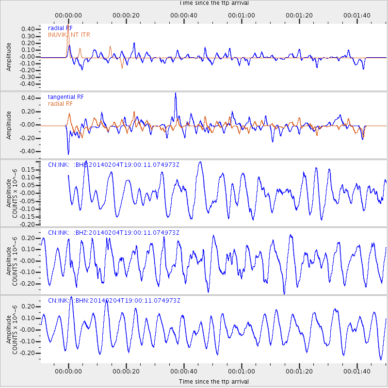
INK INUVIK, NT - Earthquake Result Viewer
*The percent match for this event was below the threshold and hence no stack was calculated.
| Earthquake location: |
Mariana Islands |
| Earthquake latitude/longitude: |
13.4/144.2 |
| Earthquake time(UTC): |
2014/02/04 (035) 18:49:16 GMT |
| Earthquake Depth: |
135 km |
| Earthquake Magnitude: |
5.2 MW |
| Earthquake Catalog/Contributor: |
ISC/ISC |
|
| Network: |
CN Canadian National Seismograph Network |
| Station: |
INK INUVIK, NT |
| Lat/Lon: |
68.31 N/133.53 W |
| Elevation: |
44 m |
|
| Distance: |
74.8 deg |
| Az: |
22.442 deg |
| Baz: |
267.864 deg |
| Ray Param: |
$rayparam |
*The percent match for this event was below the threshold and hence was not used in the summary stack. |
|
| Radial Match: |
45.505905 % |
| Radial Bump: |
400 |
| Transverse Match: |
62.238987 % |
| Transverse Bump: |
400 |
| SOD ConfigId: |
3390531 |
| Insert Time: |
2019-04-10 05:43:05.521 +0000 |
| GWidth: |
2.5 |
| Max Bumps: |
400 |
| Tol: |
0.001 |
|
Signal To Noise
| Channel | StoN | STA | LTA |
| CN:INK: :BHZ:20140204T19:00:11.074973Z | 1.0044653 | 1.2681835E-7 | 1.2625458E-7 |
| CN:INK: :BHN:20140204T19:00:11.074973Z | 1.7759923 | 1.5668982E-7 | 8.822663E-8 |
| CN:INK: :BHE:20140204T19:00:11.074973Z | 1.0433522 | 8.470243E-8 | 8.118296E-8 |
| Arrivals |
| Ps | |
| PpPs | |
| PsPs/PpSs | |


