You are here: Home > Network List > IU - Global Seismograph Network (GSN - IRIS/USGS) Stations List
> Station FURI Mt. Furi, Ethiopia > Earthquake Result Viewer
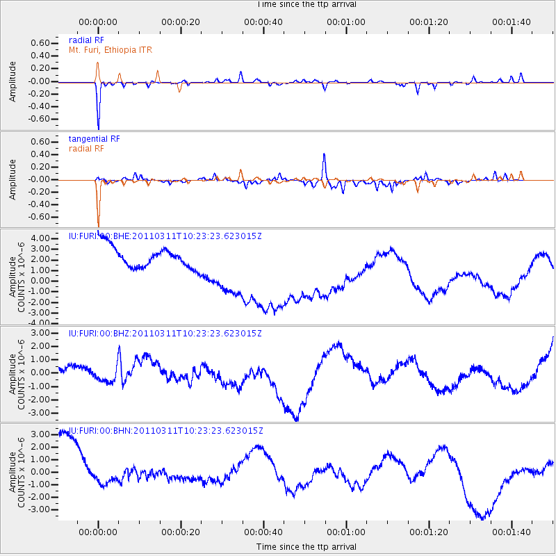
FURI Mt. Furi, Ethiopia - Earthquake Result Viewer
*The percent match for this event was below the threshold and hence no stack was calculated.
| Earthquake location: |
Near East Coast Of Honshu, Japan |
| Earthquake latitude/longitude: |
39.2/142.8 |
| Earthquake time(UTC): |
2011/03/11 (070) 10:10:34 GMT |
| Earthquake Depth: |
26 km |
| Earthquake Magnitude: |
6.0 MB |
| Earthquake Catalog/Contributor: |
WHDF/NEIC |
|
| Network: |
IU Global Seismograph Network (GSN - IRIS/USGS) |
| Station: |
FURI Mt. Furi, Ethiopia |
| Lat/Lon: |
8.90 N/38.68 E |
| Elevation: |
2570 m |
|
| Distance: |
95.2 deg |
| Az: |
285.77 deg |
| Baz: |
49.193 deg |
| Ray Param: |
$rayparam |
*The percent match for this event was below the threshold and hence was not used in the summary stack. |
|
| Radial Match: |
53.138912 % |
| Radial Bump: |
175 |
| Transverse Match: |
65.744965 % |
| Transverse Bump: |
302 |
| SOD ConfigId: |
356183 |
| Insert Time: |
2011-08-14 07:05:50.832 +0000 |
| GWidth: |
2.5 |
| Max Bumps: |
400 |
| Tol: |
0.001 |
|
Signal To Noise
| Channel | StoN | STA | LTA |
| IU:FURI:00:BHZ:20110311T10:23:23.623015Z | 1.0022058 | 1.9072112E-6 | 1.9030135E-6 |
| IU:FURI:00:BHN:20110311T10:23:23.623015Z | 0.18675831 | 4.4581773E-7 | 2.3871373E-6 |
| IU:FURI:00:BHE:20110311T10:23:23.623015Z | 3.1635165 | 3.1715795E-6 | 1.0025487E-6 |
| Arrivals |
| Ps | |
| PpPs | |
| PsPs/PpSs | |


