You are here: Home > Network List > TA - USArray Transportable Network (new EarthScope stations) Stations List
> Station 633A Saathoff Ranch, Hondo, TX, USA > Earthquake Result Viewer
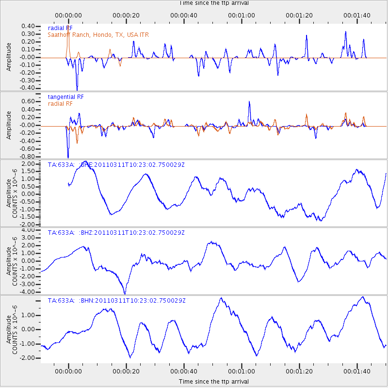
633A Saathoff Ranch, Hondo, TX, USA - Earthquake Result Viewer
*The percent match for this event was below the threshold and hence no stack was calculated.
| Earthquake location: |
Near East Coast Of Honshu, Japan |
| Earthquake latitude/longitude: |
39.2/142.8 |
| Earthquake time(UTC): |
2011/03/11 (070) 10:10:34 GMT |
| Earthquake Depth: |
26 km |
| Earthquake Magnitude: |
6.0 MB |
| Earthquake Catalog/Contributor: |
WHDF/NEIC |
|
| Network: |
TA USArray Transportable Network (new EarthScope stations) |
| Station: |
633A Saathoff Ranch, Hondo, TX, USA |
| Lat/Lon: |
29.46 N/99.18 W |
| Elevation: |
320 m |
|
| Distance: |
90.6 deg |
| Az: |
50.32 deg |
| Baz: |
316.698 deg |
| Ray Param: |
$rayparam |
*The percent match for this event was below the threshold and hence was not used in the summary stack. |
|
| Radial Match: |
64.016716 % |
| Radial Bump: |
329 |
| Transverse Match: |
51.142952 % |
| Transverse Bump: |
349 |
| SOD ConfigId: |
356183 |
| Insert Time: |
2011-08-14 07:40:09.740 +0000 |
| GWidth: |
2.5 |
| Max Bumps: |
400 |
| Tol: |
0.001 |
|
Signal To Noise
| Channel | StoN | STA | LTA |
| TA:633A: :BHZ:20110311T10:23:02.750029Z | 0.5902641 | 7.864604E-7 | 1.3323875E-6 |
| TA:633A: :BHN:20110311T10:23:02.750029Z | 0.6300097 | 1.4840406E-6 | 2.3555835E-6 |
| TA:633A: :BHE:20110311T10:23:02.750029Z | 0.80880934 | 9.0939585E-7 | 1.1243637E-6 |
| Arrivals |
| Ps | |
| PpPs | |
| PsPs/PpSs | |


