You are here: Home > Network List > TA - USArray Transportable Network (new EarthScope stations) Stations List
> Station T37A Cheneyville 1850, Columbus, KS, USA > Earthquake Result Viewer
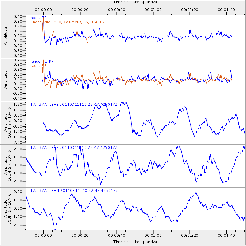
T37A Cheneyville 1850, Columbus, KS, USA - Earthquake Result Viewer
*The percent match for this event was below the threshold and hence no stack was calculated.
| Earthquake location: |
Near East Coast Of Honshu, Japan |
| Earthquake latitude/longitude: |
39.2/142.8 |
| Earthquake time(UTC): |
2011/03/11 (070) 10:10:34 GMT |
| Earthquake Depth: |
26 km |
| Earthquake Magnitude: |
6.0 MB |
| Earthquake Catalog/Contributor: |
WHDF/NEIC |
|
| Network: |
TA USArray Transportable Network (new EarthScope stations) |
| Station: |
T37A Cheneyville 1850, Columbus, KS, USA |
| Lat/Lon: |
37.12 N/94.92 W |
| Elevation: |
256 m |
|
| Distance: |
87.4 deg |
| Az: |
42.544 deg |
| Baz: |
318.894 deg |
| Ray Param: |
$rayparam |
*The percent match for this event was below the threshold and hence was not used in the summary stack. |
|
| Radial Match: |
64.40915 % |
| Radial Bump: |
350 |
| Transverse Match: |
50.587406 % |
| Transverse Bump: |
322 |
| SOD ConfigId: |
356183 |
| Insert Time: |
2011-08-14 07:48:00.753 +0000 |
| GWidth: |
2.5 |
| Max Bumps: |
400 |
| Tol: |
0.001 |
|
Signal To Noise
| Channel | StoN | STA | LTA |
| TA:T37A: :BHZ:20110311T10:22:47.425017Z | 1.5994635 | 1.0840205E-6 | 6.7774005E-7 |
| TA:T37A: :BHN:20110311T10:22:47.425017Z | 2.1502326 | 8.635411E-7 | 4.016036E-7 |
| TA:T37A: :BHE:20110311T10:22:47.425017Z | 6.3677363 | 2.1217245E-6 | 3.3319918E-7 |
| Arrivals |
| Ps | |
| PpPs | |
| PsPs/PpSs | |


