You are here: Home > Network List > TA - USArray Transportable Network (new EarthScope stations) Stations List
> Station A04D Lummi Island, WA, USA > Earthquake Result Viewer
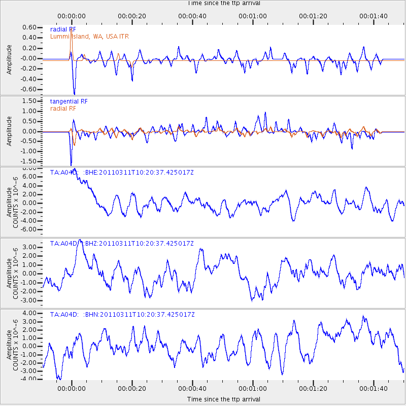
A04D Lummi Island, WA, USA - Earthquake Result Viewer
*The percent match for this event was below the threshold and hence no stack was calculated.
| Earthquake location: |
Near East Coast Of Honshu, Japan |
| Earthquake latitude/longitude: |
39.2/142.8 |
| Earthquake time(UTC): |
2011/03/11 (070) 10:10:34 GMT |
| Earthquake Depth: |
26 km |
| Earthquake Magnitude: |
6.0 MB |
| Earthquake Catalog/Contributor: |
WHDF/NEIC |
|
| Network: |
TA USArray Transportable Network (new EarthScope stations) |
| Station: |
A04D Lummi Island, WA, USA |
| Lat/Lon: |
48.72 N/122.71 W |
| Elevation: |
13 m |
|
| Distance: |
64.5 deg |
| Az: |
47.016 deg |
| Baz: |
300.85 deg |
| Ray Param: |
$rayparam |
*The percent match for this event was below the threshold and hence was not used in the summary stack. |
|
| Radial Match: |
51.86246 % |
| Radial Bump: |
400 |
| Transverse Match: |
66.29969 % |
| Transverse Bump: |
400 |
| SOD ConfigId: |
356183 |
| Insert Time: |
2011-08-14 07:52:41.895 +0000 |
| GWidth: |
2.5 |
| Max Bumps: |
400 |
| Tol: |
0.001 |
|
Signal To Noise
| Channel | StoN | STA | LTA |
| TA:A04D: :BHZ:20110311T10:20:37.425017Z | 2.259076 | 2.6498476E-6 | 1.1729785E-6 |
| TA:A04D: :BHN:20110311T10:20:37.425017Z | 0.5235318 | 1.7782664E-6 | 3.3966733E-6 |
| TA:A04D: :BHE:20110311T10:20:37.425017Z | 0.55710256 | 1.7168969E-6 | 3.0818328E-6 |
| Arrivals |
| Ps | |
| PpPs | |
| PsPs/PpSs | |


