You are here: Home > Network List > TA - USArray Transportable Network (new EarthScope stations) Stations List
> Station N54A Moraine State Park, Portersville, PA, USA > Earthquake Result Viewer
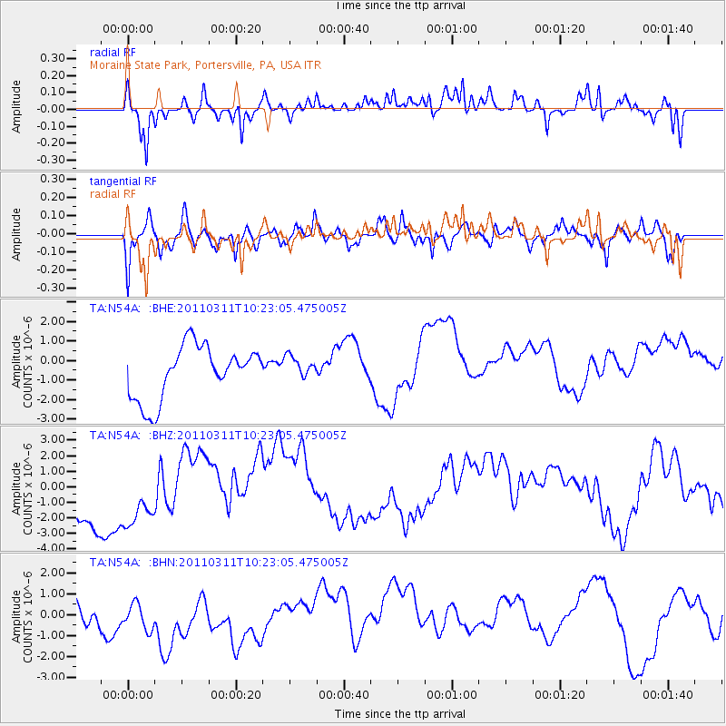
N54A Moraine State Park, Portersville, PA, USA - Earthquake Result Viewer
*The percent match for this event was below the threshold and hence no stack was calculated.
| Earthquake location: |
Near East Coast Of Honshu, Japan |
| Earthquake latitude/longitude: |
39.2/142.8 |
| Earthquake time(UTC): |
2011/03/11 (070) 10:10:34 GMT |
| Earthquake Depth: |
26 km |
| Earthquake Magnitude: |
6.0 MB |
| Earthquake Catalog/Contributor: |
WHDF/NEIC |
|
| Network: |
TA USArray Transportable Network (new EarthScope stations) |
| Station: |
N54A Moraine State Park, Portersville, PA, USA |
| Lat/Lon: |
40.96 N/79.99 W |
| Elevation: |
408 m |
|
| Distance: |
91.2 deg |
| Az: |
30.943 deg |
| Baz: |
328.152 deg |
| Ray Param: |
$rayparam |
*The percent match for this event was below the threshold and hence was not used in the summary stack. |
|
| Radial Match: |
58.77094 % |
| Radial Bump: |
395 |
| Transverse Match: |
64.7759 % |
| Transverse Bump: |
400 |
| SOD ConfigId: |
356183 |
| Insert Time: |
2011-08-14 07:58:26.134 +0000 |
| GWidth: |
2.5 |
| Max Bumps: |
400 |
| Tol: |
0.001 |
|
Signal To Noise
| Channel | StoN | STA | LTA |
| TA:N54A: :BHZ:20110311T10:23:05.475005Z | 1.2332033 | 2.3690864E-6 | 1.9210834E-6 |
| TA:N54A: :BHN:20110311T10:23:05.475005Z | 0.93132013 | 1.3832366E-6 | 1.4852428E-6 |
| TA:N54A: :BHE:20110311T10:23:05.475005Z | 0.4349486 | 5.915906E-7 | 1.3601391E-6 |
| Arrivals |
| Ps | |
| PpPs | |
| PsPs/PpSs | |


