You are here: Home > Network List > US - United States National Seismic Network Stations List
> Station DGMT Dagmar, Montana, USA > Earthquake Result Viewer
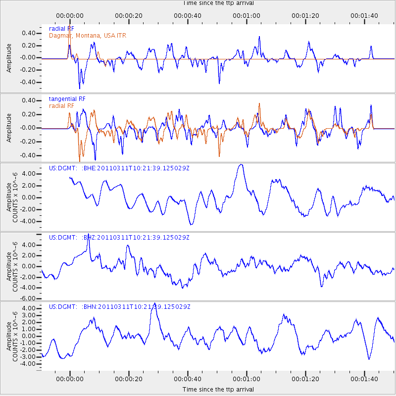
DGMT Dagmar, Montana, USA - Earthquake Result Viewer
*The percent match for this event was below the threshold and hence no stack was calculated.
| Earthquake location: |
Near East Coast Of Honshu, Japan |
| Earthquake latitude/longitude: |
39.2/142.8 |
| Earthquake time(UTC): |
2011/03/11 (070) 10:10:34 GMT |
| Earthquake Depth: |
26 km |
| Earthquake Magnitude: |
6.0 MB |
| Earthquake Catalog/Contributor: |
WHDF/NEIC |
|
| Network: |
US United States National Seismic Network |
| Station: |
DGMT Dagmar, Montana, USA |
| Lat/Lon: |
48.47 N/104.20 W |
| Elevation: |
0.0 m |
|
| Distance: |
74.5 deg |
| Az: |
39.458 deg |
| Baz: |
312.085 deg |
| Ray Param: |
$rayparam |
*The percent match for this event was below the threshold and hence was not used in the summary stack. |
|
| Radial Match: |
74.72647 % |
| Radial Bump: |
400 |
| Transverse Match: |
51.193623 % |
| Transverse Bump: |
400 |
| SOD ConfigId: |
356183 |
| Insert Time: |
2011-08-14 08:12:00.063 +0000 |
| GWidth: |
2.5 |
| Max Bumps: |
400 |
| Tol: |
0.001 |
|
Signal To Noise
| Channel | StoN | STA | LTA |
| US:DGMT: :BHZ:20110311T10:21:39.125029Z | 2.9236028 | 3.1837303E-6 | 1.088975E-6 |
| US:DGMT: :BHN:20110311T10:21:39.125029Z | 0.83504194 | 2.3181935E-6 | 2.7761403E-6 |
| US:DGMT: :BHE:20110311T10:21:39.125029Z | 1.6000855 | 2.3281077E-6 | 1.4549895E-6 |
| Arrivals |
| Ps | |
| PpPs | |
| PsPs/PpSs | |


