You are here: Home > Network List > AZ - ANZA Regional Network Stations List
> Station LVA2 AZ.LVA2 > Earthquake Result Viewer
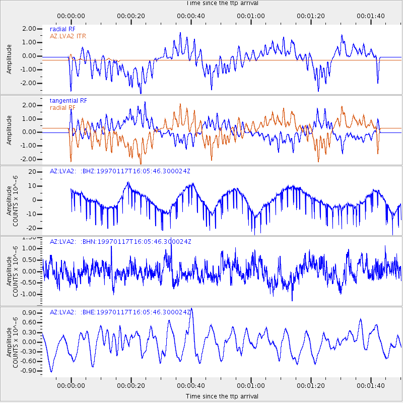
LVA2 AZ.LVA2 - Earthquake Result Viewer
*The percent match for this event was below the threshold and hence no stack was calculated.
| Earthquake location: |
Ryukyu Islands, Japan |
| Earthquake latitude/longitude: |
28.8/130.0 |
| Earthquake time(UTC): |
1997/01/17 (017) 15:53:13 GMT |
| Earthquake Depth: |
33 km |
| Earthquake Magnitude: |
5.9 MB, 6.3 MS, 6.3 UNKNOWN, 6.2 MW |
| Earthquake Catalog/Contributor: |
WHDF/NEIC |
|
| Network: |
AZ ANZA Regional Network |
| Station: |
LVA2 AZ.LVA2 |
| Lat/Lon: |
33.35 N/116.56 W |
| Elevation: |
1435 m |
|
| Distance: |
91.7 deg |
| Az: |
50.176 deg |
| Baz: |
306.368 deg |
| Ray Param: |
$rayparam |
*The percent match for this event was below the threshold and hence was not used in the summary stack. |
|
| Radial Match: |
34.63765 % |
| Radial Bump: |
353 |
| Transverse Match: |
34.201683 % |
| Transverse Bump: |
316 |
| SOD ConfigId: |
4480 |
| Insert Time: |
2010-02-26 19:52:20.585 +0000 |
| GWidth: |
2.5 |
| Max Bumps: |
400 |
| Tol: |
0.001 |
|
Signal To Noise
| Channel | StoN | STA | LTA |
| AZ:LVA2: :BHN:19970117T16:05:46.300024Z | 0.9421709 | 3.465953E-7 | 3.678688E-7 |
| AZ:LVA2: :BHE:19970117T16:05:46.300024Z | 0.99901444 | 3.376774E-7 | 3.3801052E-7 |
| AZ:LVA2: :BHZ:19970117T16:05:46.300024Z | 1.5098945 | 8.825813E-6 | 5.8453174E-6 |
| Arrivals |
| Ps | |
| PpPs | |
| PsPs/PpSs | |


